

In recent years, the agricultural industry has undergone a technological revolution, with precision agriculture emerging as a game-changer. At the heart of this revolution lies AG GPS Surveying System RTK technology, offering a suite of solutions tailored to the unique needs of modern farming practices. From field mapping to machinery guidance, AG GPS has transformed traditional farming methods, enhancing efficiency, productivity, and sustainability.
Field Mapping: Navigating Agricultural Terrain
The Importance of Accurate Field Mapping
Field mapping forms the cornerstone of agricultural management, providing farmers with crucial insights into their land's characteristics and potential. AG GPS technology revolutionizes field mapping by offering precise and real-time data, enabling farmers to create detailed maps of their fields with unprecedented accuracy.
Enhancing Precision with Satellite-Based Mapping
AG GPS leverages satellite-based navigation systems to accurately delineate field boundaries, identify topographical variations, and assess soil properties. By integrating GPS data with Geographic Information Systems (GIS), farmers gain a comprehensive understanding of their fields, facilitating informed decision-making and resource allocation.
Optimizing Crop Distribution and Management
With precise field maps generated by AG GPS Surveying System RTK, farmers can optimize crop distribution and management strategies. By analyzing soil composition, moisture levels, and other factors, farmers can tailor planting patterns and irrigation schedules to maximize yield potential while minimizing resource wastage.
Improving Sustainability through Precision Mapping
AG GPS technology empowers farmers to adopt sustainable land management practices by identifying areas prone to erosion, nutrient depletion, or waterlogging. Armed with this knowledge, farmers can implement targeted conservation measures, such as precision tillage and cover cropping, to mitigate environmental degradation and enhance soil health.
Crop Monitoring: Real-Time Insights for Enhanced Yield
Monitoring Crop Health and Development
Effective crop monitoring is essential for maximizing yield and minimizing losses throughout the growing season. AG GPS technology enables real-time monitoring of crop health and development, allowing farmers to identify potential issues early and take proactive measures to address them.
Utilizing Remote Sensing and Imaging Technologies
AG GPS integrates remote sensing and imaging technologies, such as drones and satellite imagery, to provide comprehensive crop monitoring solutions. By capturing high-resolution images of agricultural fields, farmers can assess crop health, detect pest infestations, and evaluate the efficacy of agronomic treatments with unparalleled precision.
Facilitating Data-Driven Decision Making
The real-time data provided by AG GPS empowers farmers to make data-driven decisions regarding crop management. By monitoring factors such as soil moisture levels, temperature fluctuations, and nutrient availability, farmers can adjust irrigation, fertilization, and pest control strategies in response to changing environmental conditions, maximizing crop yields while minimizing inputs.
Enhancing Crop Quality and Marketability
By closely monitoring crop health and development, farmers can optimize harvest timing and ensure the production of high-quality, marketable crops. AG GPS technology enables farmers to track crop maturity, moisture content, and other quality parameters, facilitating timely harvesting and post-harvest handling practices to preserve crop quality and enhance market value.
Precision Farming: Maximizing Efficiency and Sustainability
The Evolution of Precision Farming
Precision farming represents a paradigm shift in agricultural management, moving away from one-size-fits-all approaches towards site-specific optimization. AG GPS Surveying System RTK lies at the heart of precision farming, enabling farmers to customize inputs, monitor performance, and maximize efficiency across their operations.
Customizing Inputs with Variable Rate Technology
AG GPS facilitates the implementation of Variable Rate Technology (VRT), allowing farmers to apply inputs such as seeds, fertilizers, and pesticides at variable rates based on field-specific conditions. By tailoring input applications to match soil fertility levels, yield potential, and other factors, farmers can optimize resource utilization and minimize waste, leading to cost savings and environmental benefits.
Improving Machinery Efficiency and Accuracy
AG GPS technology enhances machinery guidance and automation systems, improving efficiency and accuracy in field operations. By integrating GPS guidance systems with farm machinery such as tractors, planters, and harvesters, farmers can precisely navigate fields, minimize overlap, and reduce input costs while maximizing coverage and productivity.
Reducing Environmental Footprint
Precision farming powered by AG GPS Surveying System RTK offers significant environmental benefits by reducing the environmental footprint of agricultural operations. By optimizing input applications and minimizing unnecessary field passes, farmers can reduce soil erosion, nutrient runoff, and pesticide drift, preserving natural resources and minimizing negative impacts on ecosystems and water quality.
Machinery Guidance: Navigating Fields with Precision
The Role of AG GPS Surveying System RTK in Machinery Guidance
Machinery guidance is critical for ensuring precise and efficient field operations, from planting and spraying to harvesting. AG GPS technology revolutionizes machinery guidance systems, offering farmers unparalleled precision, reliability, and ease of use.
Enhancing Accuracy and Efficiency
AG GPS enables centimeter-level accuracy in machinery guidance, allowing farmers to navigate fields with precision and confidence. By eliminating guesswork and minimizing human error, AG GPS technology improves efficiency in field operations, reducing input costs and enhancing overall productivity.
Minimizing Overlaps and Wastage
One of the key benefits of AG GPS technology in machinery guidance is the ability to minimize overlaps and reduce input wastage. By precisely guiding machinery along predetermined paths, farmers can eliminate double coverage and minimize input overlaps, leading to significant cost savings and resource conservation.
Enabling Autonomous and Semi-Autonomous Operations
AG GPS technology paves the way for autonomous and semi-autonomous field operations, reducing the need for manual intervention and labor requirements. By equipping farm machinery with GPS guidance systems and automation technologies, farmers can streamline operations, increase operational flexibility, and optimize labor utilization, especially during peak seasons.
High Precision for Precision Agriculture
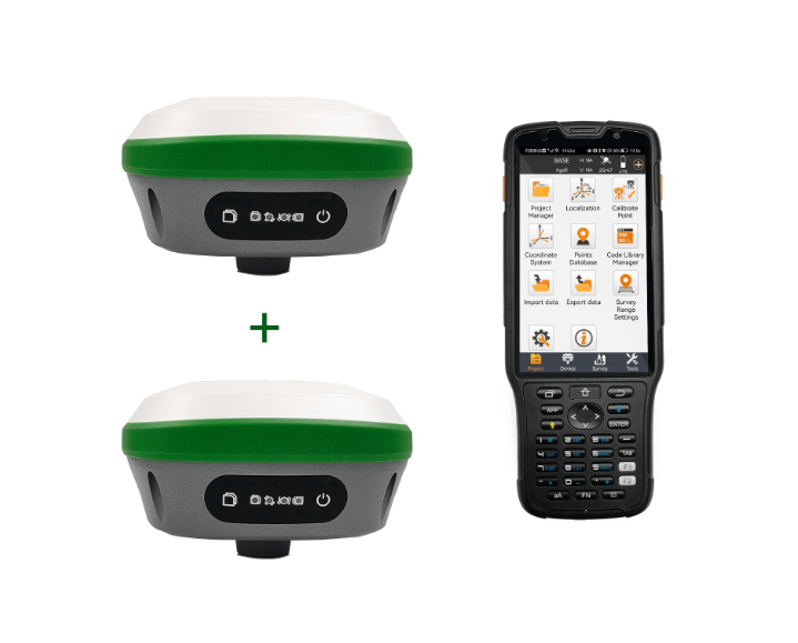
Introducing the R26 GNSS Receiver
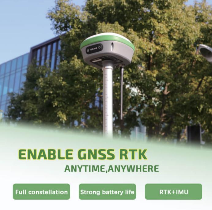
At the core of the R26 Surveying System lies its advanced GNSS receiver, capable of receiving global corrections services delivered via both satellite and internet channels. This cutting-edge technology enables centimeter-level positioning accuracy, providing farmers with unprecedented precision in their field operations. By supporting multi-satellite systems and full-band satellite signal reception, the R26 ensures reliable and accurate positioning even in challenging environments.
Enhanced Satellite Signal Reception
One of the key features of the R26 is its ability to support multi-satellite systems and receive full-band satellite signals. This feature enables the receiver to utilize signals from GPS, Glonass, BeiDou, Galileo and QZSS constellations. Maximizes satellite coverage and improves signal tracking efficiency. Equipped with a high-gain antenna, the R26 improves signal tracking efficiency by up to 50%. It provides survey-grade positioning data, giving farmers the accuracy they need to make informed decisions.
Centimeter-Level Precision in Seconds
The R26 GNSS RTK survey system excels at providing fast and precise positioning data. Centimeter-level accuracy is achieved in seconds. This fast response time is critical for time-sensitive agricultural tasks such as planting, spraying, and harvesting. Real-time data can play a major role in optimizing efficiency and maximizing yields. Furthermore, the R26 maintains reliable fixed RTK accuracy even in typically challenging environments, ensuring consistent performance regardless of field conditions.
Engineered for Field Use
Design and Integration
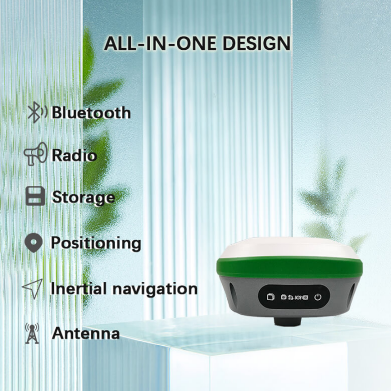
The R26 Surveying System Rover+Base is engineered with the ruggedness and reliability required for field use in agricultural settings. It adopts an integrated design with built-in large-capacity battery and memory card. No external power supply or data storage device is required, and it also integrates a multi-functional high-precision inertial navigation RTK receiver independently developed by SMAJAYU. Its positioning and orientation capabilities are further improved.
Versatile Connectivity
In addition to GNSS capabilities, the R26 also comes with a range of connectivity options. to facilitate data transfer and communication. With built-in Bluetooth, radio and inertial navigation modules. The receiver integrates seamlessly into existing agricultural workflows. Realize wireless data exchange and remote monitoring. This versatility enables farmers to access real-time positioning data and monitor field operations from anywhere, enhancing operational flexibility and efficiency.
Robust Performance in Field Conditions
The R26 measurement system is designed to withstand the harsh conditions of field use. Its rugged construction withstands harsh environmental conditions. Whether operating in dusty fields, humid climates or extreme temperatures, the R26 maintains its performance and reliability. Ensure uninterrupted data collection and transfer. Its durable design and sturdy construction make it the ideal companion for agricultural professionals looking for a reliable positioning solution for their daily operations.
Empowering Precision Agriculture
Optimizing Farming Operations
The R26 survey system Rover+Base features centimeter-level positioning accuracy and fast response time. It helps farmers optimize their agricultural operations with unparalleled accuracy. Whether it is field mapping, crop monitoring, precision agriculture or machine guidance. The R26 provides the accuracy and reliability needed to make informed decisions and maximize productivity. By harnessing the power of GNSS technology. Farmers can achieve new levels of efficiency, sustainability and profitability in their agricultural practices.
Improving Crop Management
The precise location data provided by R26 enables farmers to implement precision crop management practices based on the specific needs of their fields. Monitor crop health and optimize input application by accurately mapping soil characteristics. Farmers can maximize yields while minimizing resource waste and environmental impact. R26’s ability to provide real-time location data ensures farmers can adjust management strategies in a timely manner. Effectively respond to changing conditions and optimize crop performance.
Enhancing Machinery Guidance
The R26's advanced GNSS capabilities also extend to machinery guidance, allowing farmers to navigate their fields with precision and efficiency. By integrating the R26 with agricultural machinery such as tractors, planters and harvesters. Farmers can minimize overlap, reduce input costs, and maximize coverage. Thereby improving work efficiency and productivity. The receiver's powerful performance and reliable accuracy ensure smooth, precise operation even in challenging field conditions. Allowing farmers to get the best results every time.
Conclusion
AG GPS Surveying System RTK represents a transformative force in modern agriculture, offering a comprehensive suite of solutions to meet the diverse needs of farmers worldwide. From field mapping and crop monitoring to precision agriculture and machinery navigation. AG GPS enables farmers to optimize resource utilization, increase productivity and promote sustainability across their operations. As technology continues to evolve, AG GPS will continue to be at the forefront of innovation. Driving the agricultural industry toward a more efficient, resilient and sustainable future.
