

Picture this: you're about to embark on a pivotal construction project, only to discover—much to your dismay—that the surveying data you’re relying on is flawed. Such inaccuracies could set off a chain reaction of expensive errors, schedule disruptions, and even potential safety hazards. Engineering surveying serves as the bedrock of numerous civil, infrastructural, and geospatial initiatives, and the reliability of your results is directly tied to the precision of your Engineering Surveying Equipment. In this article, we’ll delve into the critical role that proper calibration plays in ensuring accuracy, discuss cost-effective yet high-performing tools, and examine cutting-edge technologies reshaping the surveying landscape. Additionally, we’ll take an in-depth look at one of the top-rated tools available today: the SMA26 RTK GNSS receiver.
The Significance of Calibrating Surveying Equipment for Accurate Outcomes
Accuracy stands as one of the most essential pillars of engineering surveying. Even the most sophisticated, state-of-the-art instruments are vulnerable to providing erroneous readings if they are not correctly calibrated. Calibration is the process that fine-tunes Engineering Surveying Equipment to ensure it is capturing measurements—whether distances, angles, or positions—with the utmost precision. This becomes especially vital when dealing with large-scale endeavors, where even the smallest measurement error could cascade into substantial deviations and costly mistakes.
Why Proper Calibration Is Crucial
The act of calibrating brings the Engineering Surveying Equipment’s measurements into alignment with established reference standards, ensuring that surveyors can have full confidence in the data they gather. In the absence of proper calibration, devices such as total stations, GPS receivers, and theodolites may produce inconsistent or inaccurate results. These inaccuracies could lead to construction teams placing structures in the wrong locations or miscalculating critical elevations, thus causing waste of resources, project setbacks, and soaring costs.
The Calibration Process: Step-by-Step
The procedure for calibrating surveying instruments generally entails comparing the readings from the tool to a known reference point and then making adjustments to the device accordingly. For instance, a total station might need calibration for both its horizontal and vertical angle measurements. Ensuring regular calibration is paramount, particularly when Engineering Surveying Equipment is employed in demanding conditions where external variables—like fluctuating temperatures, humidity levels, or nearby magnetic fields—can influence accuracy.
Sustaining Accuracy Over Time
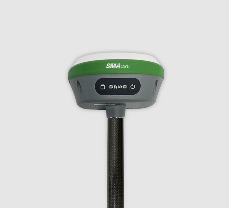
Relying on tools such as the SMA26 RTK GNSS receiver, equipped with advanced built-in intelligence, can significantly help surveyors uphold long-term precision. Designed to conduct self-diagnostics and provide voice prompts, the SMA26 minimizes the chances of inaccurate readings due to miscalibration. Its user-friendly system aids surveyors in maintaining peak accuracy, regardless of environmental conditions or project duration.
Engineering Surveying on a Budget: Affordable Tools That Deliver High Accuracy
Not all engineering projects have large budgets, but that doesn't mean sacrificing accuracy is an option. Fortunately, there are affordable tools on the market that offer precision without breaking the bank. Whether you're a small contractor or a local surveyor, there are reliable, budget-friendly options that will meet your needs.
Finding Cost-Effective Solutions
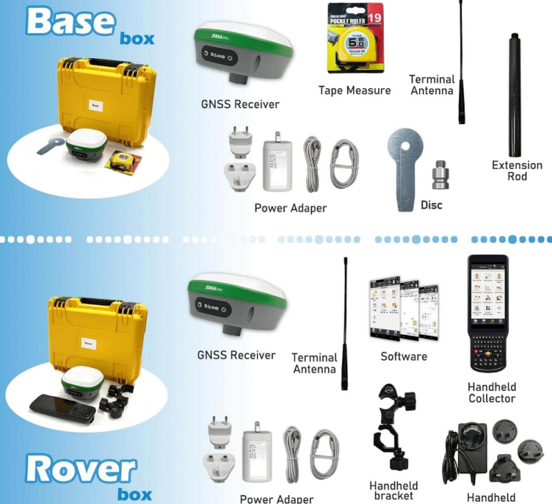
When working with limited resources, it's essential to find tools that offer the most value for their price. The SMA26 RTK GNSS receiver is an example of a device that balances cost and performance. Priced at $1,136, it provides high-precision positioning with built-in GNSS full-frequency antennas, high-capacity batteries, and multi-constellation tracking capabilities. This makes it an excellent choice for surveying projects requiring accuracy and affordability.
Prioritizing Versatility
One of the key factors to consider when purchasing budget-friendly equipment is versatility. The SMA26 can be used as both a mobile station and a base station, making it suitable for various surveying tasks, from construction layouts to topographic mapping. It supports positioning needs across industries like precision agriculture, drone surveying, and mine exploration.
Maintaining Accuracy on a Budget
Another advantage of modern surveying technology is its capacity to maintain accuracy even in low-cost models. The SMA26 RTK features a built-in IMU (Inertial Measurement Unit) that enables the device to remain precise even in environments where signal reception may be compromised. Its ability to receive satellite signals from multiple constellations ensures accurate positioning, even in remote or complex environments.
What to Look for When Purchasing Engineering Surveying Equipment
Choosing the right engineering surveying equipment can be overwhelming given the number of options available. Whether you’re upgrading your toolkit or starting fresh, understanding what features are most important will help you make a smart investment.
Precision and Accuracy
First and foremost, precision should be your top priority. Devices like the SMA26 RTK GNSS receiver, which boasts 1408 channels and signal tracking for all constellations, provide highly accurate readings in real-time. For projects requiring precise measurements—such as geodetic surveys, construction layouts, or aerial drone mapping—choosing equipment with multi-constellation support is crucial.
Battery Life and Durability
Long-lasting battery life is essential, especially for outdoor or remote projects. The SMA26 has a built-in battery with a capacity of 10,200mAh, allowing for more than 14 hours of continuous operation. This feature ensures that the tool can operate effectively in the field without needing constant recharging, making it ideal for long-term surveys in harsh environments.
Connectivity and Software Integration
Surveying tools should seamlessly integrate with modern software solutions for easy data management. The SMA26 supports both wireless UHF protocols and 4G connectivity, allowing for real-time data transfer and remote access. Its intelligent platform (WEBUI) enables users to control the device and monitor its performance from a web browser, enhancing overall project efficiency.
Leveraging Mobile Mapping Technology in Engineering Surveying
In recent years, mobile mapping technology has become an invaluable tool in the field of engineering surveying. This technology allows surveyors to collect data more quickly and accurately by using portable devices equipped with advanced sensors.
The Advantages of Mobile Mapping
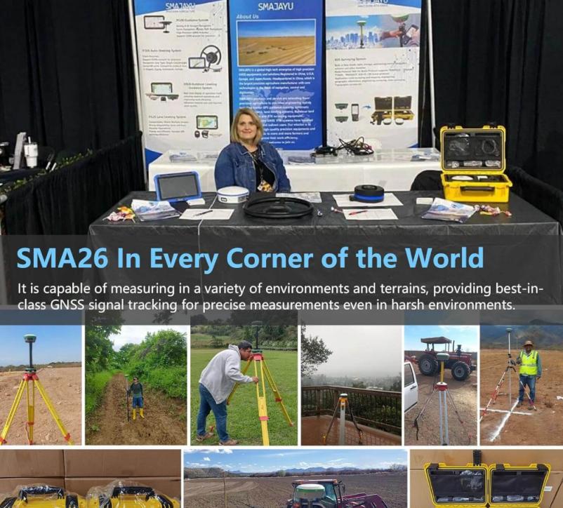
Mobile mapping offers significant advantages, such as the ability to gather data in real-time and create detailed 3D models of the surveyed area. This can drastically reduce the amount of time spent in the field while increasing the quality and depth of the data collected. Systems like the SMA26 RTK, which feature multi-constellation GNSS tracking, enable accurate mobile mapping even in complex or obstructed environments.
Flexibility and Efficiency
Mobile mapping technology allows surveyors to cover larger areas more efficiently. The portability of devices like the SMA26 GNSS rover makes it easier to navigate difficult terrain while still gathering accurate data. This efficiency is particularly beneficial for large-scale projects, such as city planning, infrastructure development, and natural resource management.
Integration with UAVs and Drones
One of the most exciting developments in mobile mapping is its integration with unmanned aerial vehicles (UAVs) and drones. The SMA26 RTK is compatible with drone systems, making it an ideal choice for aerial surveying and topographical data collection. This capability is especially useful for mapping large or hard-to-reach areas.
From Tripods to Theodolites: A Deep Dive into Engineering Surveying Gear
Engineering surveying requires a wide range of tools, each with its own specific function. While advanced technologies like the SMA26 RTK GNSS receiver are transforming the industry, traditional equipment still plays a vital role in many projects.
Theodolites and Total Stations
Theodolites and total stations are two of the most commonly used instruments in surveying. Theodolites measure horizontal and vertical angles, while total stations combine this functionality with distance measurement. These tools are essential for projects requiring high precision over short distances, such as construction layouts or boundary surveys.
Tripods and Leveling Equipment
Tripods and leveling equipment ensure that the devices remain stable and accurate during surveys. A stable setup is particularly important when using high-precision tools like the SMA26 RTK GNSS receiver, which requires a solid base to ensure accurate measurements in the field.
Laser Scanners and LiDAR
Laser scanners and LiDAR technology have become increasingly popular in recent years due to their ability to create detailed 3D models of the surveyed area. These tools are especially useful for projects like road construction, where understanding the topography is critical for accurate planning.
Conclusion
In engineering surveying, accuracy and reliability are non-negotiable. The right equipment can make all the difference, whether you’re working on a tight budget or using the latest technology like the SMA26 RTK GNSS receiver. From traditional theodolites to mobile mapping systems, understanding your project’s needs and selecting the right tools is key to delivering successful results. For those looking for an affordable, high-performance solution, the SMA26 RTK offers the perfect balance of precision, versatility, and value.
