

Precision agriculture is revolutionizing the way farming is conducted by introducing data-driven, high-tech solutions. But how do farmers make informed decisions based on this advanced technology? The answer lies in engineering surveys and services. These tools offer accurate, real-time information that helps farmers manage land, optimize resources, and improve productivity.
Why Farmers Need Engineering Surveys and Services for Precision Agriculture
Farmers face numerous challenges, such as unpredictable weather patterns, soil variability, and water management. Without precise data, making informed decisions can be difficult, leading to inefficient use of resources and potential crop loss. Engineering surveys address these problems by providing accurate land measurements, topographic data, and resource distribution insights.
Farmers need detailed information about their fields’ topography to plan efficient irrigation systems, manage soil erosion, and maximize land use. Surveys also allow them to monitor field conditions and adjust crop planting strategies based on precise terrain data. Additionally, Engineering Surveys and Services support machinery automation, enabling precision in planting, fertilization, and harvesting.
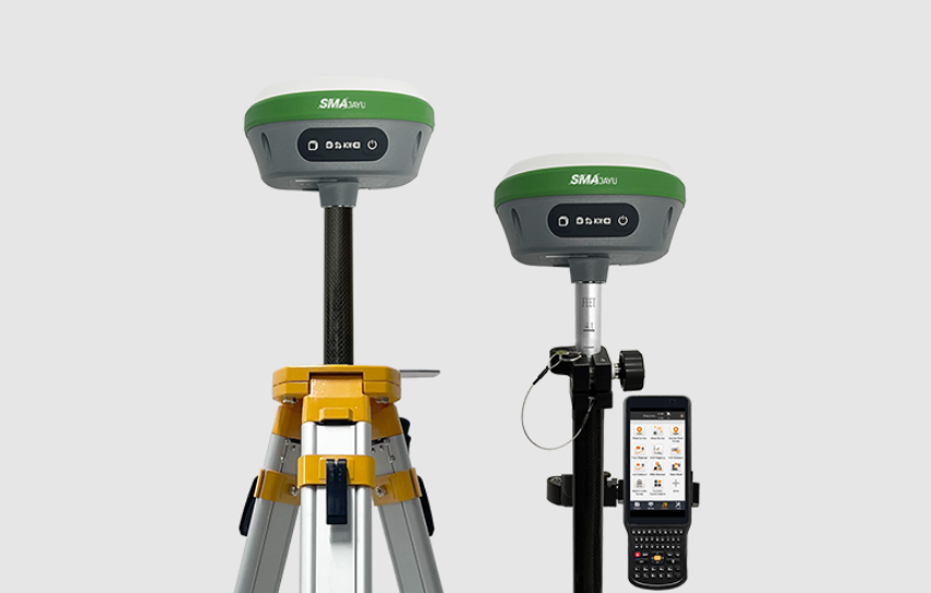
One of the primary tools that make these Engineering Surveys and Services possible is the SMA26 GNSS Surveying System, which offers high-precision positioning and data collection. The ability to track and analyze this data allows farmers to make critical decisions, from crop rotation to resource management.
Meeting the Demand for High-Precision Data in Agriculture
Modern agriculture requires accurate data to manage the growing complexity of farming operations. The rise of GPS technology and GNSS (Global Navigation Satellite Systems) receivers like the SMA26 has significantly advanced the field of precision agriculture.
The SMA26 RTK+Tripod, priced at $2,735.00, is a state-of-the-art GNSS receiver designed for high-precision data collection. It boasts a 100% recommendation rate, showing its reliability and efficiency in engineering surveys for precision agriculture.
What Makes SMA26 Essential for Precision Agriculture?
Multi-functional and Intelligent
The SMA26 GNSS receiver is not just any ordinary tool—it’s a multi-functional and intelligent system. Built with a GNSS full-frequency antenna and high-precision positioning board, it is equipped with 4G, IMU (Inertial Measurement Unit), radio, and other modules. This technology ensures farmers get the most accurate data, even in harsh and complex agricultural environments.
Large Capacity and Long Battery Life
Farming operations, especially in large fields, often require long working hours. The SMA26 comes with a built-in battery with a capacity of up to 10,200mAh, offering more than 14 hours of continuous operation. This is critical for farmers who need to conduct surveys across multiple acres without worrying about power outages.
Built-In UHF Wireless and Advanced Protocols
The SMA26 also features a built-in low-power transceiver with a wireless module that automatically switches between mobile and base stations. This simplifies the process, allowing farmers to focus on data collection without manual intervention. The CSS (Lora) wireless protocol ensures reliable and long-distance communication between devices, a crucial feature for large-scale farms.
The Role of Trends and Technology in Precision Agriculture Surveys
Precision agriculture isn’t just about collecting data—it’s about utilizing cutting-edge technology to interpret and apply that data for better farming outcomes. Engineering Surveys and Services in agriculture have evolved with the rise of GPS and GNSS technology, enabling farmers to access high-precision data like never before.
The Rise of GNSS Receivers in Agriculture
GNSS receivers have become a game-changer for precision farming. The SMA26 GNSS surveying system is particularly popular due to its ability to receive satellite signals from all constellations and all frequency points. It is compatible with Beidou-3 and can search for more than 40 satellites, ensuring positioning accuracy even in complex environments. This level of precision allows farmers to conduct highly detailed surveys for planning irrigation, monitoring crop health, and managing land resources.

Integration with Drones and Automated Machinery
Engineering Surveys and Services are increasingly integrated with drones and automated machinery to further streamline agricultural processes. Drones equipped with GNSS receivers can capture aerial images of fields, which are then used to create highly detailed maps. This allows farmers to detect issues such as crop stress, water distribution problems, or pest infestations early, minimizing damage and optimizing yield.
Moreover, automated machinery, guided by GNSS technology like the SMA26, can precisely plant seeds, apply fertilizers, and harvest crops. This level of automation reduces human error, increases efficiency, and ensures the optimum use of resources.
The Future of Engineering Surveys in Agriculture
As precision agriculture continues to evolve, engineering surveys and services will play an even more critical role in driving innovation. The ability to collect accurate, real-time data allows farmers to anticipate problems, manage resources effectively, and reduce costs.
Expanded Use of GNSS Technology
The demand for GNSS technology is expected to grow, particularly as the benefits of accurate data collection become more apparent. Devices like the SMA26 will continue to be indispensable for agricultural operations, particularly those focused on sustainability and resource conservation.
In addition to its agricultural applications, the SMA26 can be used for various other purposes such as mechanical control, surveying and mapping engineering, geographical information systems, water surveying, and aerial photography. Its versatility makes it a valuable tool across industries, but its benefits are especially pronounced in agriculture, where precision is paramount.

Enhanced Data Analytics and Decision-Making
The future of precision agriculture lies in the integration of GNSS technology with powerful data analytics platforms. By combining survey data with AI-powered analytics, farmers will be able to make even more informed decisions. These platforms will be able to predict crop yields, optimize resource use, and suggest improvements in real time, giving farmers a competitive edge.
Conclusion: Engineering Surveys Empowering Modern Agriculture
Engineering surveys and services, powered by devices like the SMA26 GNSS system, are the backbone of modern precision agriculture. They allow farmers to collect accurate data on land, soil, and crops, enabling them to make informed decisions that optimize yields, conserve resources, and reduce costs.
For engineering survey equipment wholesalers, the SMA26 represents an essential product that meets the growing demand for precision in agriculture. With features like long battery life, high-precision tracking, and multi-functionality, the SMA26 is a reliable tool that can meet the complex needs of today’s farmers.
By investing in GNSS technology like the SMA26, wholesalers and suppliers can support the continued growth of precision agriculture, ensuring farmers have the tools they need to succeed in a rapidly evolving industry.
