

How is technology changing agriculture? Farmers now use advanced tools to improve efficiency. Precision is important for better crop growth. Accurate land leveling helps water flow evenly. It prevents waste and improves soil health. Good leveling increases yields and saves resources.
SMAJAYU provides high-precision GNSS solutions. These tools help farmers, surveyors, and engineers. They improve positioning, orientation, and accuracy. Smart technology makes farming easier. It helps users work faster and get better results. With the right tools, agriculture becomes more efficient.
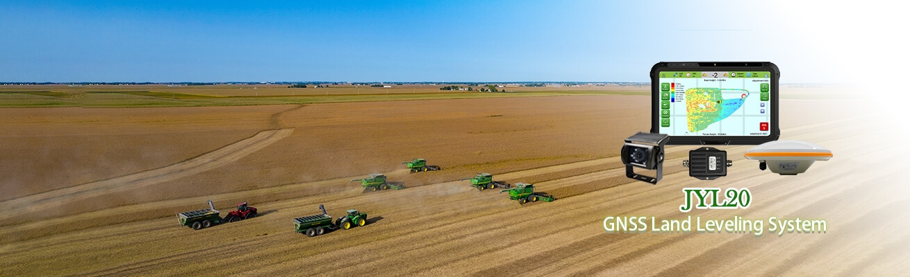
What is the JYL20 Tractor GNSS Land Leveling System?
Overview of the JYL20 Land Leveling System
The JYL20 GNSS land leveling system provides high precision for farmland operations. It delivers accurate results and ensures smooth leveling. The system includes a visual operation map for easy use.
It replaces traditional laser graders. It works with leveling shovels, scrapers, bulldozers, and graders. It guides and controls leveling machinery. It improves efficiency and reduces the need for skilled operators.
Farmers use this system for different tasks. It helps in farmland leveling, grid field transformation, and wasteland reclamation. It also supports dry land conversion and ground surface leveling. It makes farming easier and more productive.
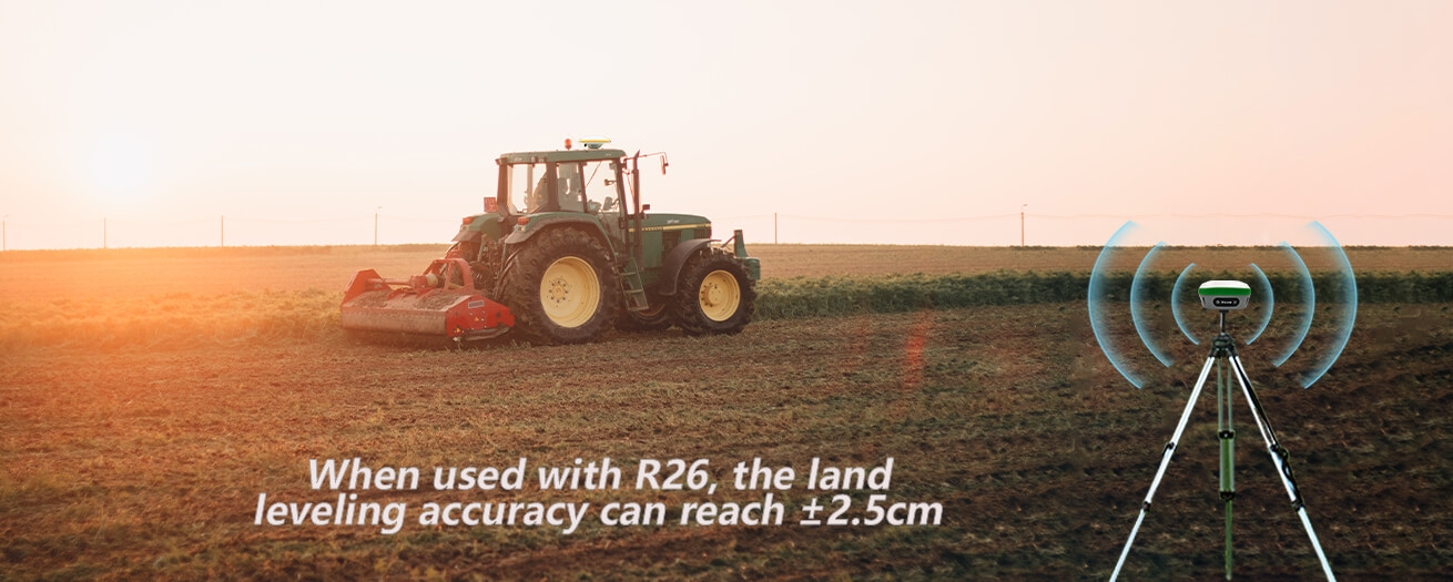
Integration with R26 RTK Base Station for Enhanced Accuracy
The JYL20 works with the R26 RTK Base Station to improve precision. When used together, the system achieves ±2.5 cm accuracy. It ensures smooth and even land surfaces.
The system tracks operations and maps terrain. It provides high and low elevation data. It increases leveling efficiency by 30%. It improves work quality and reduces time spent in the field.
No base station setup is needed. The system works without distance limits. It automatically detects terrain and adjusts leveling. This increases efficiency by 20%. It works in all conditions, including day, night, wind, and dust.
How GNSS Technology Enhances Land Leveling
Real-Time Positioning for Accurate Terrain Leveling
GNSS land leveling systems provide real-time positioning. They help create smooth and even surfaces. This improves farming efficiency.
Compared to traditional methods, GNSS leveling increases production by 20-30%. It ensures even water distribution. This improves germination and plant growth. Crops grow better, and yields increase.
Precise leveling saves water. Plants get the right amount of moisture. This prevents overwatering and reduces waste. The system creates the best conditions for crops.
Eliminating Uneven Surfaces to Improve Irrigation
Uneven fields cause problems. Water does not spread evenly. Some areas get too much, and others get too little. GNSS leveling ensures uniform water distribution. It helps fertilizers stay at the roots of plants. This reduces nutrient loss during irrigation and drainage. Smooth land improves efficiency. Farmers use less water and fertilizer. They save money and get better harvests.
R26 RTK Base Station: Ensuring Unmatched Accuracy
Centimeter-Level Positioning for Precise Land Leveling
The R26 RTK Base Station provides high-accuracy positioning. It ensures that land is leveled with precision. It allows farmers to get the best results.
The system uses real-time data. It keeps track of terrain changes. It ensures every part of the field is evenly leveled. This improves crop growth and water management.
Stability and Reliability for Uninterrupted Farming
The R26 RTK Base Station is stable and reliable. It works in all conditions. It ensures continuous operation without signal loss.
Farmers can work without interruptions. The system provides strong and accurate signals. It supports long hours of work and maintains precision.
This base station improves productivity. It helps farmers complete leveling faster. It ensures better field conditions for farming success.
Benefits for Farmers and Agricultural Efficiency
Increased Crop Yield with Better Soil and Water Distribution
A well-leveled field improves crop growth. High areas are smoothed, and low areas are filled. Water flows evenly across the land. This prevents soil erosion in high spots. It also stops water from collecting in lower areas.
Proper leveling improves plant health. Crops receive the right amount of water and nutrients. Growth becomes uniform. This leads to better yields and higher profits for farmers.
Lower Costs for Labor, Fuel, and Water
A leveled field reduces irrigation costs. Water spreads evenly. No area gets too much or too little. This prevents waste and saves resources.
Farmers also save on fuel and labor. Less time is needed for field preparation. Tractors use less fuel. Workers complete tasks faster with greater accuracy. Farming becomes more efficient and cost-effective.
Versatile Applications Across Agriculture
Saving Measurement Costs
Measuring land elevation no longer requires a survey team. Farmers can do it themselves. The GNSS Land Leveling System makes it easy.
With a few minutes of training, anyone can measure land accurately. The system provides real-time elevation data. It reduces the need for outside help and lowers costs.
Compatible with Common Leveling Machinery
The system works with standard farming equipment. It can replace laser graders. It integrates with levelers, scrapers, bulldozers, and graders. It guides and controls these machines for precise land leveling. Operators experience less fatigue. The system reduces manual adjustments. It simplifies the work and improves accuracy. Farmers use it for various tasks. It helps in farmland leveling, grid field transformation, and wasteland reclamation. It is also useful for dry-to-wet land conversion and site preparation.
Smart Features for Seamless Operation
Information Upload and Remote Monitoring
Farmers can track their work in real time. The system supports information uploads. It records working status, hours, location, and area coverage.
Users access this data through a platform or WeChat applet. This improves management. Farmers monitor operations remotely and make informed decisions.
Compatibility with Other Smart Farming Systems
The GNSS Land Leveling System works with multiple technologies. It connects to autopilot systems, intelligent spraying, and driving assistance tools.
Farmers save money by integrating systems. They do not need separate equipment for each function. This makes smart farming more affordable.
For more details on operation, users can check the system manual. The system improves efficiency, reduces workload, and enhances precision.
Upgrade Your Farming with GNSS Land Leveling!
Want better crop yields? The GNSS Land Leveling System makes farming easier. It levels land with high precision. It saves water, fuel, and labor.
No need for expensive survey teams. The system works with common farming equipment. It improves irrigation and crop growth. Farmers get higher efficiency and lower costs.
Smart features allow real-time tracking. Monitor work from anywhere. Connect with autopilot and spraying systems. Get more done with less effort.
Start using our GNSS Land Leveling today for smarter, faster, and more efficient farming!
