

GIS surveys are essential for capturing, storing, and analyzing spatial data across various industries. Leveraging the advanced R26 Rover by SMAJAYU provides a competitive edge in this field. The R26 Rover, with its all-in-one design and innovative features like an inertial module and automatic pole tilt compensation, ensures precise, centimeter-level positioning accuracy. Its versatility in operating modes and support for numerous file formats make it an indispensable tool for tasks ranging from topographic surveys to precision agriculture. By integrating the R26 Rover into their workflows, professionals can achieve higher accuracy and efficiency, driving better decision-making and resource management.

What is GIS Survey
Geographic Information System (GIS) surveys are essential in capturing, storing, analyzing, and managing spatial and geographic data. They play a crucial role in a variety of industries, including urban planning, environmental science, agriculture, and more. By integrating data from various sources, GIS surveys provide a comprehensive view of the terrain and infrastructure, enabling informed decision-making and efficient resource management.
GIS surveys rely on advanced technology to collect precise and accurate data. These surveys typically use GNSS (Global Navigation Satellite System) receivers to measure exact locations on the Earth's surface. The collected data can be used to create detailed maps, track changes over time, and analyze spatial relationships.
The Role of R26 Rover in GIS Surveys
Introduction to R26 Rover
The R26 Rover, a cutting-edge GNSS surveying rover, is designed to enhance the efficiency and accuracy of GIS surveys. Developed by SMAJAYU, the R26 Rover integrates advanced features and innovative technology to provide reliable and precise data collection in various surveying applications.
The R26 Rover GNSS Surveying System includes the R26 V1 Rover, the LP80 Collector, and the R26 RTK Receiver. Certified by NOAA for its high standards, the R26 Rover supports static surveys, RTK (Real-Time Kinematic) surveys, topographic and land surveys, and corrections through CORS (Continuously Operating Reference Stations). Its versatility makes it a valuable tool for professionals in the field of GIS surveying.
Features of the R26 Rover
The R26 Rover boasts several features that set it apart from other GNSS surveying systems. Its all-in-one design includes built-in Bluetooth, wireless connectivity, storage, positioning, inertial navigation, and an integrated antenna. These features meet the diverse needs of measurement work, making the R26 Rover a comprehensive solution for GIS surveys.
One of the standout innovations of the R26 Rover is its inertial module, which provides automatic pole tilt compensation. This feature ensures accurate measurements even when the pole is not perfectly vertical, significantly improving the efficiency and precision of data collection.
Operating Modes and File Formats
The R26 Rover offers two operating modes: base station mode and rover mode. Users can switch between these modes based on their specific needs, providing flexibility and adaptability in various surveying scenarios. In base station mode, the R26 Rover acts as a reference point, while in rover mode, it operates as a mobile unit collecting data.
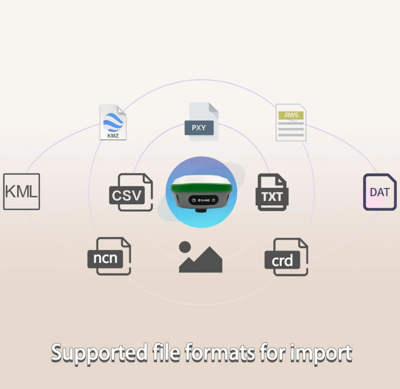
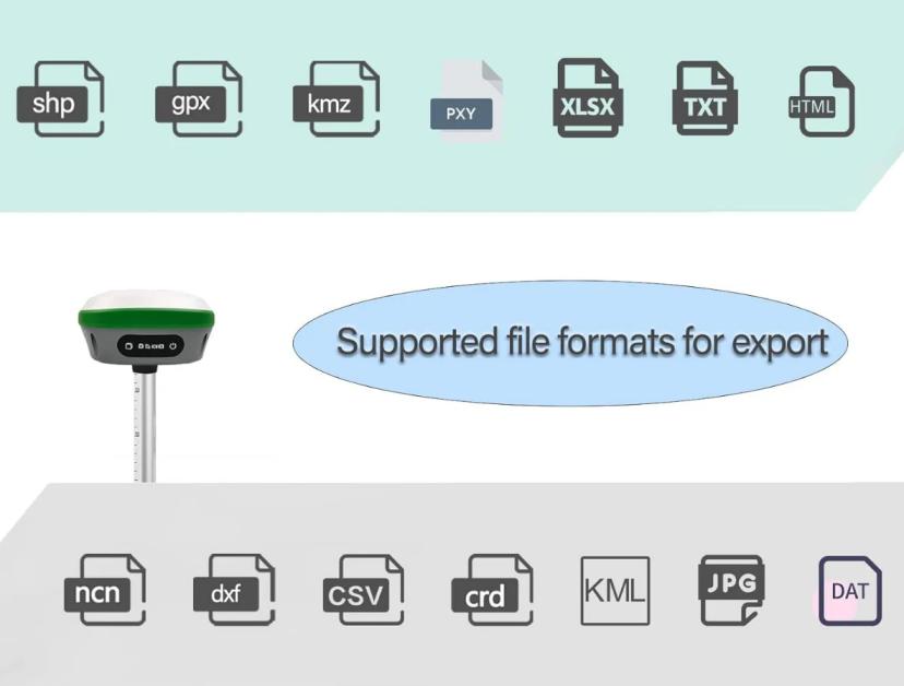
The R26 Rover supports a wide range of file formats for both import and export, including dat, txt, csv, rw5, raw, kml, kmz, ncn, pxy, crd for import, and dat, txt, csv, dxf, shp, kml, kmz, gpx, jpg, html, xls, ncn, pxy, crd for export. This compatibility ensures seamless integration with other software and systems, enhancing the versatility of the R26 Rover in GIS surveys.
Importance of R26 Rover in Precision Agriculture
Enhancing Accuracy in Agriculture
Precision agriculture relies heavily on accurate and timely data to optimize farming practices. The R26 Rover plays a critical role in this field by providing centimeter-level positioning accuracy, which is essential for tasks such as soil sampling, field mapping, and crop monitoring. By using the R26 Rover, farmers can make data-driven decisions that improve crop yields and reduce resource wastage.
Improving Efficiency in Field Operations
The compact and easy-to-carry design of the R26 Rover makes it an ideal tool for field operations in agriculture. Its GNSS receiver can receive global corrections service via satellite and internet, ensuring high accuracy regardless of the location. This capability allows farmers to conduct surveys quickly and efficiently, minimizing downtime and maximizing productivity.

Data Integration and Analysis
The R26 Rover's ability to export data in various formats facilitates seamless integration with agricultural management software. This integration enables farmers to analyze data effectively, identify patterns, and implement precision farming techniques. The resulting insights help in optimizing irrigation, fertilization, and pest control, ultimately leading to sustainable agricultural practices.
Using the R26 Rover for GIS Surveys
Setting Up the R26 Rover
To begin using the R26 Rover for GIS surveys, users need to set up the device by following a few simple steps. First, ensure that the GNSS receiver, LP80 Collector, and RTK Receiver are fully charged and connected. Then, configure the device settings according to the specific requirements of the survey, such as selecting the appropriate coordinate system and correction type (wireless, CORS, TCP/IP).
Conducting a Survey
Once the setup is complete, users can start the survey by placing the R26 Rover in rover mode. The device will begin collecting data points, which can be viewed in real-time on the LP80 Collector. For static surveys, the R26 Rover should remain stationary at specific points to collect accurate positional data. For RTK surveys, the device will use real-time corrections to provide highly precise measurements as it moves across the survey area.
Data Processing and Export
After completing the survey, the collected data can be processed and exported in the desired format. The R26 Rover supports a variety of file formats, making it easy to transfer data to GIS software for further analysis. Users can convert text format files to RINEX format using the SMAJAYU convert tool if needed. The processed data can then be used to create detailed maps, conduct spatial analysis, and generate reports.
Conclusion
The R26 Rover by SMAJAYU offers a competitive advantage in the GIS survey market by providing a reliable, accurate, and versatile solution for data collection. Its innovative features, such as the inertial module and automatic pole tilt compensation, ensure precise measurements, while its compact design and ease of use make it suitable for a wide range of applications, including precision agriculture.
By leveraging the capabilities of the R26 Rover, professionals in the field of GIS surveying can enhance their efficiency, accuracy, and overall performance. This advanced GNSS surveying system is a valuable tool for anyone looking to gain a competitive edge in the fiercely competitive market of GIS surveys.
