

Accurate data is essential for environmental monitoring. Scientists analyze land, water, and air, but tracking small changes can be challenging. Precise tools are necessary, yet traditional methods often fall short in accuracy, require significant time, and are prone to errors, making data less reliable.

How can this issue be addressed? GNSS RTK offers a solution. By providing real-time corrections, it enhances positioning accuracy, allowing researchers to detect fine details and work more efficiently. This technology improves the effectiveness of environmental studies. But what sets GNSS RTK apart? How does it benefit scientists? Let's explore its functionality and significance.
Understanding GNSS RTK and Its Advantages
What is GNSS RTK (Real-Time Kinematic)?
GNSS RTK is a positioning technology. It stands for Global Navigation Satellite System Real-Time Kinematic. It helps measure locations with high accuracy. It works by using satellite signals. A base station sends corrections to a rover. The rover receives the data. Then, it calculates the exact position. The system updates in real time. This makes measurements more precise. Many fields use this technology. Scientists and engineers need accurate data. GNSS RTK helps them get better results. But why is this technology important?
Key Benefits of GNSS RTK
GNSS RTK has many advantages. It gives centimeter-level accuracy. Other positioning methods are less precise. It also provides real-time corrections. This means data is always up to date. The system is efficient. It helps users save time. It also reduces errors. Better accuracy leads to better decisions. Researchers rely on good data. GNSS RTK makes their work easier. But where can they use it?
Applications in Environmental Data Collection
GNSS RTK helps in many ways. Scientists use it to map landscapes. It helps track environmental changes. It is useful in water monitoring. It helps study soil and vegetation. It also helps in disaster response. Teams can assess damage quickly. The technology is also used in climate research. Small changes can be detected over time. Wildlife researchers also use it. They track animal movements with more accuracy. GNSS RTK improves data collection. It makes studies more reliable.
Introducing the SMA26 GNSS RTK: A Game-Changer in Precision Monitoring
Overview of SMA26 RTK and Its Features
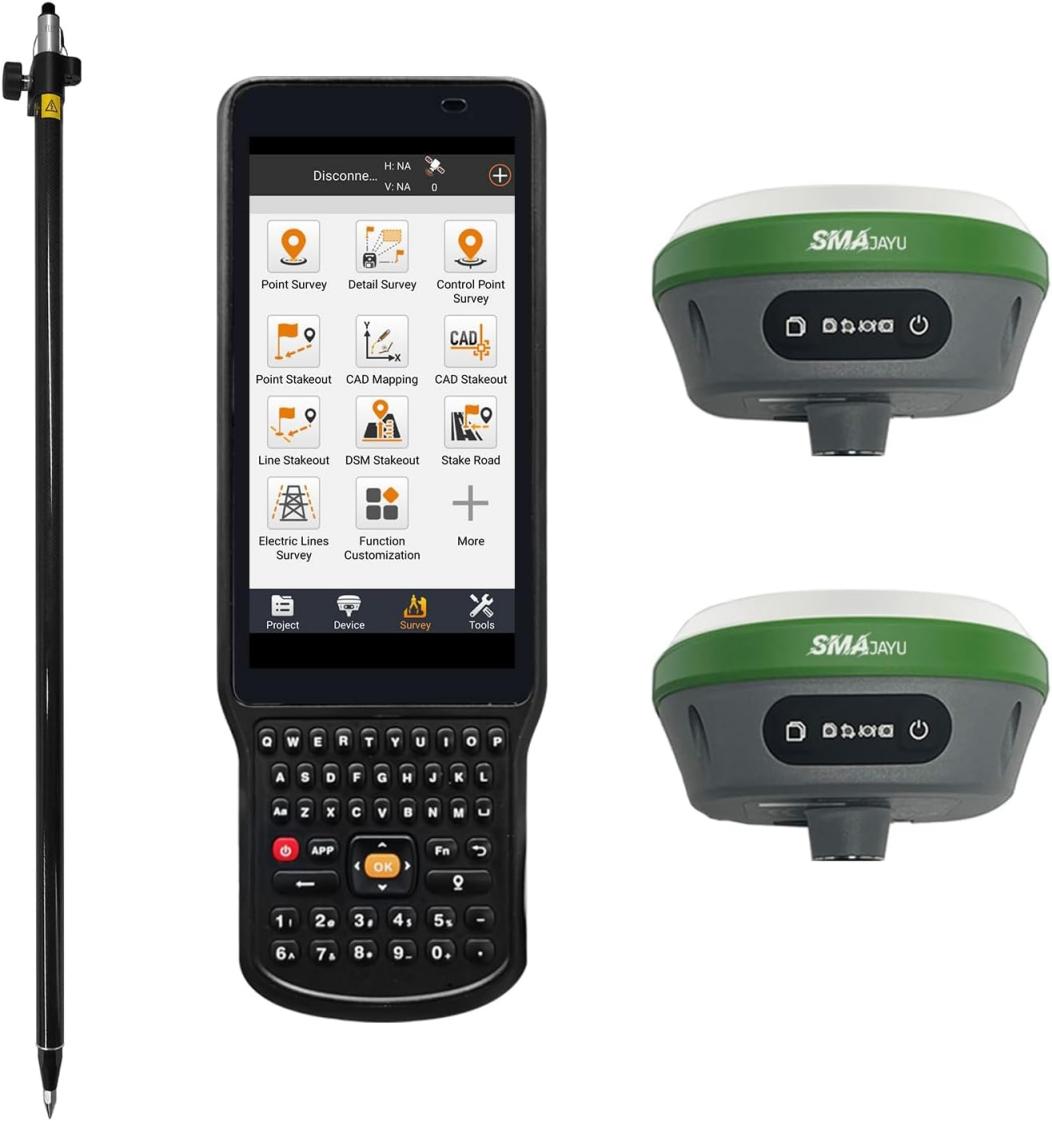
The SMA26 RTK is a high-precision GNSS receiver. It can work as a mobile station or a base station. It is small and lightweight. This makes it easy to carry and operate. It also has low power consumption. The built-in intelligent system supports voice functions, a smart web page platform (WEBUI), and a self-test feature. These make it user-friendly. It is designed for different industries. It is useful in mechanical control, surveying, precision agriculture, and geographic studies. It is also used in water and mine surveying, aerial photography, and drones. Many professionals choose SMA26 RTK because it meets their positioning and orientation needs. But what makes it better than other receivers?
How SMA26 GNSS RTK Improves Real-Time Positioning and Accuracy
SMA26 RTK is a multi-functional GNSS receiver. It has a built-in GNSS full-frequency antenna. It also includes a high-precision positioning board. The system supports 4G, IMU, and radio modules. The SMA26 GNSS Surveying System comes with a rover, a base station, and surveying software. The system works with two SMA26 RTK GNSS receivers. These allow fast and precise measurements. It receives signals from multiple satellite constellations. It is compatible with BeiDou-3. It can track over 40 satellites at the same time. This ensures accuracy even in difficult environments.
The battery has a large capacity of 10,200mAh. It can last for more than 14 hours. This makes it reliable for long outdoor operations. It also has a built-in UHF wireless module. This allows automatic switching between mobile and base stations. The device supports CSS (Lora) protocol. It has 1,408 tracking channels based on NebulasIV technology. These features make it a powerful tool. But how does it compare to other GNSS receivers?
Advantages Over Conventional GNSS Receivers
SMA26 RTK has many advantages. It is more precise than traditional GNSS receivers. It provides real-time corrections, which improves positioning accuracy. The device is easy to use. Its smart system simplifies operations. The battery lasts longer than most conventional models. The system is also more efficient. It can track more satellites. This ensures better performance in different environments. SMA26 RTK is reliable. It is designed for professionals who need high accuracy. But why should users choose SMAJAYU?
Why Choose SMAJAYU?
SMAJAYU: A Leader in GNSS Technology
SMAJAYU has over 15 years of experience. It started with traditional devices. Now, it develops smart and advanced GNSS equipment. The company focuses on precision technology. Its mission is to improve solutions for agriculture, engineering, and surveying. Many industries trust SMAJAYU for accurate positioning tools.
Strengths of SMAJAYU
SMAJAYU has a strong team. It has more than 10 talented engineers. They develop new and innovative solutions. The company has over 100 dedicated staff members. They ensure product quality and customer satisfaction. The workhouse is 1,000 square meters. It is a center for research and production. Over 10,000 customers trust SMAJAYU. This shows the company's commitment to excellence.
Global Reach and Customer Trust
SMAJAYU products are widely used around the world. They are popular in North America, South America, and Europe. Many professionals rely on these products for their projects. The company continues to expand. It provides high-quality GNSS solutions to more industries. SMAJAYU is a trusted name in precision technology.
Applications of SMA26 GNSS RTK in Environmental Monitoring
Wildlife Tracking and Habitat Mapping
Scientists study animals to understand their movements. They track wildlife to learn about migration and behavior. But how can they do this with accuracy? SMA26 GNSS RTK helps researchers pinpoint exact locations. They place GPS collars on animals. The system records their movement in real time. This helps experts see how animals use their habitats. It also helps identify areas that need protection.
Habitat mapping is also important. Researchers need precise maps of forests, wetlands, and grasslands. Traditional mapping methods take a lot of time. They are also less accurate. SMA26 GNSS RTK makes the process faster and more precise. It helps scientists monitor changes in the environment. They can study how human activities affect wildlife. This data helps in conservation efforts.
Climate Change Studies and Coastal Erosion Monitoring
Climate change affects the environment. Scientists need accurate data to measure these changes. Small shifts in land, sea levels, and temperature can have big effects. SMA26 GNSS RTK helps track these changes with high accuracy. It measures land movement and rising water levels. Researchers can study how landscapes change over time.
Coastal erosion is also a serious problem. Waves and storms wear away shorelines. This affects both nature and human settlements. Monitoring these changes helps in planning protection measures. SMA26 GNSS RTK collects precise data on coastline shifts. Scientists use this information to predict future risks. This helps governments and communities prepare for coastal changes.
Precision Agriculture and Forestry Management
Farmers need accurate data for better crop management. They must plant, water, and harvest at the right time. SMA26 GNSS RTK helps farmers work with precision. It allows them to map fields, monitor soil conditions, and apply fertilizers accurately. This reduces waste and increases productivity. It also helps in irrigation planning. Farmers save water and improve crop yields.
Forests also need careful management. Logging, conservation, and reforestation require accurate mapping. Traditional methods can be slow and less precise. SMA26 GNSS RTK helps map forests quickly. It tracks tree growth, forest density, and land changes. This helps in protecting natural resources. It also improves forest restoration projects.
Impact of SMA26 RTK in Environmental Monitoring
Success Stories Showcasing the Effectiveness of SMA26 RTK
Many researchers use SMA26 GNSS RTK for environmental projects. In one case, scientists tracked endangered animals in remote areas. They used the system to collect real-time data. This helped them understand migration patterns and threats. Conservation groups used this data to protect habitats.
Another project focused on coastal erosion. Scientists used SMA26 GNSS RTK to map shorelines. The system helped them measure erosion rates with high accuracy. This allowed local authorities to take action and prevent further damage.
Improved Data Collection in Ecological Research Projects
Researchers need reliable tools for ecological studies. SMA26 GNSS RTK improves data collection in the field. In forest research, experts used it to map tree species. They recorded growth patterns and land changes. This helped in creating better conservation plans.
In wetland studies, scientists measured water levels and land shifts. SMA26 GNSS RTK provided accurate results. The data helped in understanding climate impacts on wetlands. The system made research faster and more effective.
Testimonials from Environmental Scientists and Researchers
Scientists trust SMA26 GNSS RTK for its accuracy.
Dr. Lisa M., Wildlife Biologist: "Tracking animal movements is now faster and more precise. Data collection is seamless."
Dr. Robert T., Coastal Researcher: "SMA26 RTK provides real-time erosion data, making it more reliable than older methods."
Emily S., Forestry Expert: "Tree mapping is more efficient. Conservation planning has never been this accurate."
SMA26 GNSS RTK improves research efficiency, helping professionals collect precise environmental data.
Get Accurate Data with SMA26 GNSS RTK
SMA26 GNSS RTK gives high precision. It helps scientists track wildlife and map forests. It measures coastal erosion and land changes. It works fast and reduces errors. Many experts trust it. They use it for research and conservation. Choose SMA26 GNSS RTK for better results. Get yours today!
