

What is GNSS RTK, and why are topographic surveyors embracing this advanced technology? For over 15 years, SMAJAYU has transitioned from traditional devices to modern, intelligent equipment. Our high-precision GNSS technology has revolutionized the way we operate, enhancing accuracy in precision farming, engineering, and surveying.
GNSS RTK streamlines data collection, making it faster and more precise. As a result, professionals across various industries now rely on this method for superior results. Curious about how this technology boosts accuracy? Let's explore why GNSS RTK is a game-changer for multiple applications.
Behind the Scenes: How GNSS RTK Works
A Smart and Portable Device
The SMA26 works as a mobile station or a base station. It has high accuracy. It uses little power. It is small and easy to carry. Anyone can operate it without trouble. It has a built-in smart system. This system includes voice support, a web platform (WEBUI), and a self-check function. These features make it more convenient for users. The SMA26 helps users work faster and with fewer mistakes.
Supports Many Industries
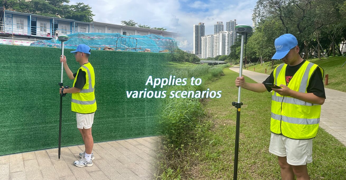
The SMA26 helps different industries. It is used for machine control, land surveying, and precision farming. It is also useful in geographic mapping, water measurement, and mine surveys. Many people in engineering and aerial photography also use it. Drone operators rely on it for better navigation. Because of its accuracy, it is a good choice for professionals in many fields.
Built for High Performance
The SMA26 is a powerful GNSS receiver. It has a full-frequency GNSS antenna inside. It also has a high-accuracy positioning board. It includes 4G, IMU, and radio modules. These features make it reliable for many tasks. It can collect data quickly and correctly. It works well in difficult conditions. Many users trust it for precise results.
Beyond Traditional Limits: The GNSS RTK Advantage
Easy and Accurate Point Calibration
To calibrate a point, you need coordinates from two systems. The target system has known points or imported coordinates. The current system gets real-time coordinates using RTK. It is best to use at least three points. Their coordinates must match in both systems. This makes sure the calibration is correct.
A Complete Surveying System
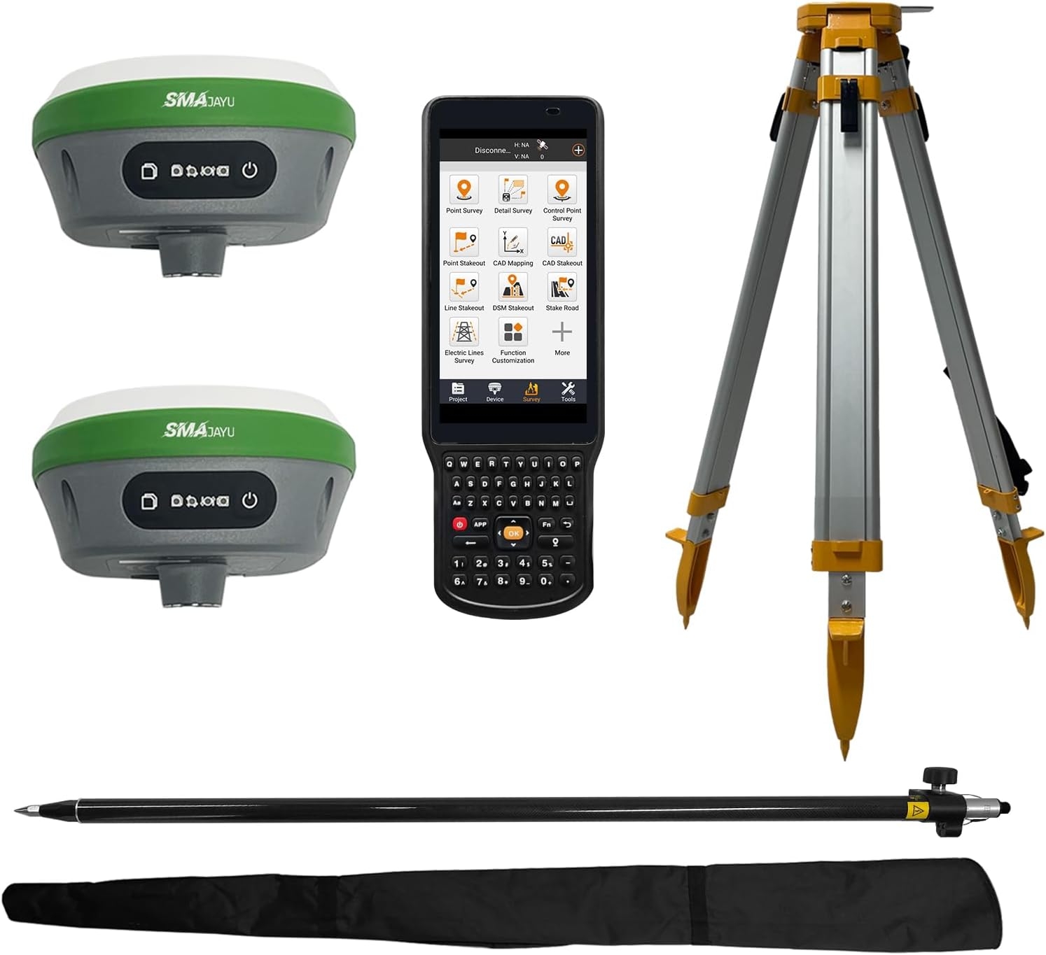
The SMA26 GNSS Surveying System comes with everything needed. It includes an SMA26 rover, a base station, and a collector with surveying software. Two SMA26 RTK GNSS receivers are part of the system. These help measure and mark locations with great accuracy. The system provides fast and precise results.
Strong Signal Reception
The SMA26 receives satellite signals from all constellations. It supports Beidou-3. It can track more than 40 satellites. This ensures good positioning, even in tough environments. The strong signal helps users get accurate results anywhere. Even in places with obstacles, it maintains precision.
Mapping New Opportunities: Industries Benefiting from SMA26 RTK
Helping Civil Engineering and Construction
Civil engineers and construction workers use SMA26 RTK for precise measurements. It helps in designing roads, bridges, and buildings. Workers can measure land with high accuracy. This reduces mistakes and saves time. It also improves safety by preventing errors in construction plans. Many companies rely on SMA26 RTK for their projects.
Better Results in Environmental Management
Environmental experts use SMA26 RTK to study landscapes. They track changes in forests, rivers, and coastal areas. This helps them protect natural resources. Scientists also use it to monitor climate change. With accurate data, they can make better decisions. SMA26 RTK allows them to measure land and water levels in real-time. This makes their work more effective.
Success Stories in Different Projects
Many industries have seen better results with SMA26 RTK. Construction projects finish faster with fewer errors. Farmers grow crops more efficiently with precise mapping. Engineers build safer roads and bridges. Environmentalists track land changes more accurately. These success stories show how SMA26 RTK improves work in different fields.
Common Problems with SMA26 RTK
Using GNSS RTK can sometimes be difficult. Poor signal strength in cities or forests can cause delays. Harsh weather can also affect accuracy. Another challenge is learning how to use the system properly. If workers do not understand the technology, they may make mistakes. Battery life is also important for long hours in the field.
Simple Solutions for Better Performance
To fix signal problems, users can work in open areas. If that is not possible, they can use advanced receivers to improve accuracy. Training sessions help workers understand how to use the system correctly. This prevents errors and increases efficiency. Long battery life also helps. The built-in 10200mAh battery in SMA26 RTK devices lasts more than 14 hours. This allows users to work all day without stopping.
Strong Signal and Wireless Features
The system has 1408 channels. It is based on NebulasIV technology. This helps users track signals from different satellites. The built-in UHF wireless module allows automatic switching between mobile and base stations. The CSS (LoRa) protocol ensures stable communication. These features make SMA26 RTK reliable in different conditions.
Boost Accuracy with SMA26 RTK Today!
SMA26 RTK gives precise results. Engineers use it for roads and buildings. Farmers rely on it for better crop planning. Scientists track land changes with high accuracy. It works fast and reduces errors. The system has a strong signal for any location. It has a long battery life for outdoor work. Built-in wireless features allow easy switching between modes. It supports many industries. It helps users complete tasks faster and with fewer mistakes. Many professionals trust SMA26 RTK for their work. Do you want better accuracy? Start using SMA26 RTK now and see the difference!
