

Why is high-precision GPS more important than ever? Surveyors, engineers, and researchers need accurate data. Small errors can cause big problems.
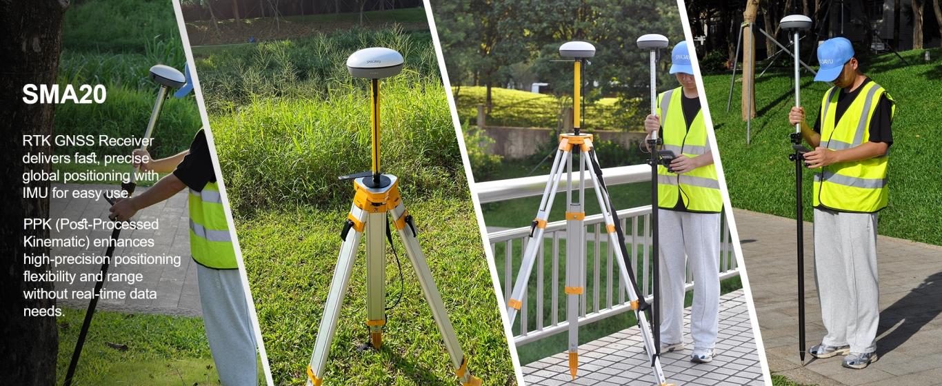
The SMA20 RTK Rover changes how professionals work. It delivers fast and accurate positioning. It works in tough environments. It has global signal coverage.
This GNSS RTK receiver is lightweight and easy to carry. It has an Inertial Measurement Unit (IMU). You don't need to check or level the bubble when measuring. The tilt survey function makes work faster and easier. It removes the hassle of leveling.
What Makes the SMA20 RTK Rover Stand Out?
Combination of RTK and PPK Capabilities
The SMA20 RTK Rover provides fast and accurate positioning. It combines Real-Time Kinematic (RTK) and Post-Processed Kinematic (PPK) technology. This dual system improves accuracy in different conditions.
The device has a built-in high-precision Inertial Measurement Unit (IMU). It includes a gyroscope and an accelerometer. These features help with tilt measurements. The GNSS and IMU work together to allow surveying at any angle. It maintains 3 cm accuracy even at a 60° tilt.
With this system, users can work faster and more efficiently. The rover removes the need for constant leveling. This makes it easier to use in the field.
Compact Design and Advanced Technology
The SMA20 RTK Rover is small and lightweight. It is easy to carry and transport. The design makes it simple to use for long hours. It features advanced GNSS technology. It maintains accuracy even in challenging environments. The combination of high precision, tilt measurement, and global signal coverage makes it ideal for surveying and mapping.
RTK vs. PPK: Understanding the Dual Capability
RTK (Real-Time Kinematic): Instant Positioning
RTK technology provides real-time, high-precision positioning. It works by using signals from base stations and satellites. This allows users to get accurate location data instantly.
RTK is useful for live applications. Surveyors, engineers, and construction workers rely on it for immediate results. It is ideal for mapping roads, land, and construction sites.
However, RTK needs a stable connection to base stations. In areas with weak signals, accuracy may decrease. This is where PPK technology becomes useful.
PPK (Post-Processed Kinematic): Enhanced Accuracy
PPK works by collecting satellite data and processing it later. It calculates precise positions after data collection. This method ensures higher accuracy, even in difficult conditions.
PPK does not need a real-time data link. It is ideal for areas with signal blockages. Urban canyons, forests, and remote locations benefit from this technology.
PPK is highly reliable. It can process data from an entire survey. It also corrects errors from temporary signal loss. This ensures complete and accurate results.
Why Both Technologies Matter
The SMA20 RTK Rover includes both RTK and PPK. This makes it flexible for different surveying conditions. Users can choose RTK for immediate accuracy or PPK for post-processed precision. With this dual capability, the device adapts to any environment. It ensures high-quality data, whether in the field or during post-processing.
High-Precision GPS Measurement in Action
How the SMA20 Ensures Centimeter-Level Accuracy
The SMA20 RTK Rover delivers precise GPS measurements. It maintains centimeter-level accuracy in real-world conditions. It works in open areas and complex terrains.
The built-in GNSS and IMU technology helps with positioning. It adjusts for tilt and movement. This ensures accurate data without needing manual leveling.
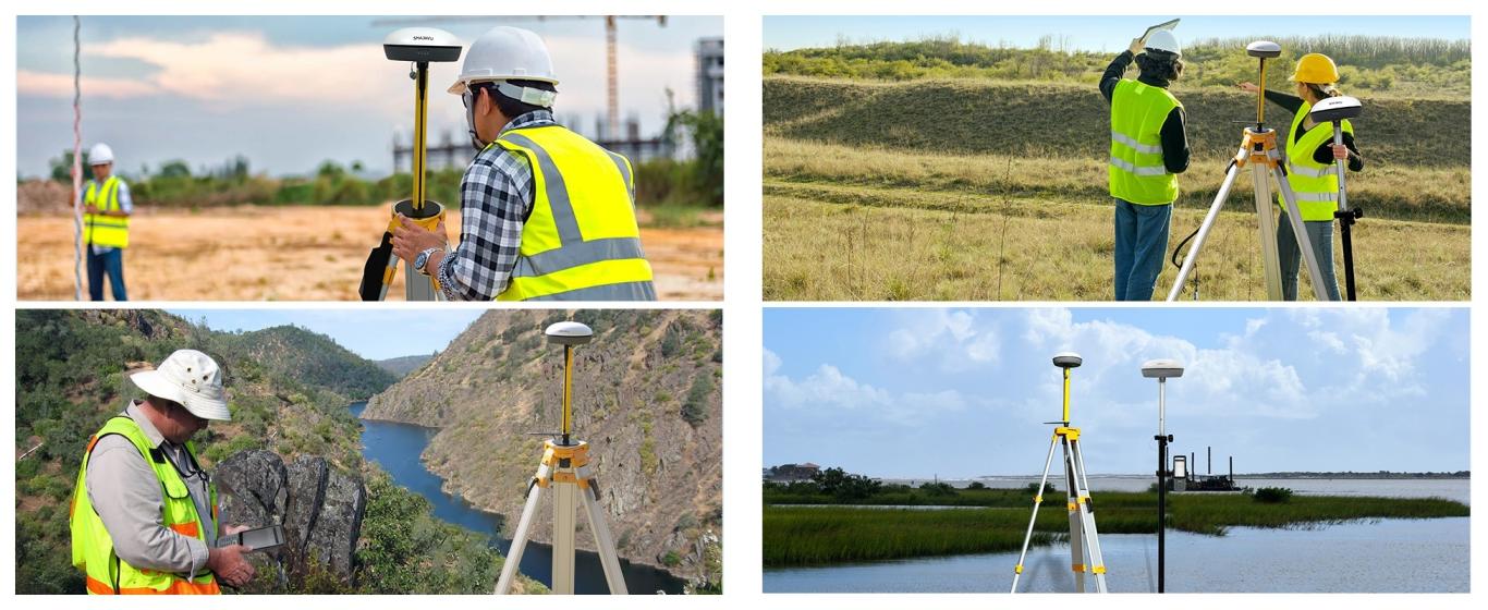
Surveyors, engineers, and researchers use it for precise mapping. It performs well in cities, forests, and remote areas. It provides stable accuracy in any location.
Industries That Benefit from High-Precision GPS
Many industries rely on accurate GPS data. Surveyors use it for boundary and land mapping. Engineers need it for construction planning. Farmers use GPS for precision agriculture. It helps with planting and spraying. Researchers track environmental changes. High-precision GPS improves efficiency across many fields.
Seamless Integration with Rover + Base Setup
How the SMA20 RTK Rover + Base System Works
The SMA20 RTK Rover works with a base station for reliable accuracy. It ensures precise measurements even in tough conditions.
PPK technology allows positioning in areas with weak signals. It does not need a real-time data link. This makes it useful in mountains, cities, and remote areas.
It also works well for large-scale projects. Highways, railroads, and pipelines require long-distance accuracy. The SMA20 handles these projects with ease.
Benefits of a Stable Connection and Strong Signal
A strong signal is important for accurate GPS data. The SMA20 has advanced satellite tracking. It keeps a stable connection even in difficult locations. A reliable signal reduces errors. Surveyors and engineers get more accurate results. The system improves efficiency and reduces the need for corrections.
Versatility Across Industries
Surveying & Land Mapping
Surveyors need precise boundary measurements. The SMA20 improves land mapping accuracy. It helps create topographic maps and property boundaries. Accurate data prevents disputes. It also helps in planning and construction. The system makes surveys faster and more reliable.
Construction & Infrastructure
Engineers need precise layouts for construction. The SMA20 ensures accuracy for roads and buildings. It improves site monitoring and safety. Precise positioning helps reduce errors. It ensures projects stay on track. It improves efficiency in construction planning.
Agriculture & Precision Farming
Farmers use GPS to manage land. The SMA20 helps with planting and spraying. It ensures even distribution of fertilizers and pesticides. Accurate mapping improves crop yields. It reduces waste and saves money. The system makes farming more efficient.
Environmental & Research Applications
Scientists track land changes over time. The SMA20 helps monitor erosion and deforestation. It collects climate data with high accuracy. Accurate GPS helps researchers study environmental shifts. It provides reliable data for long-term analysis. It supports conservation efforts.
Upgrade to SMA20 RTK Rover for Unmatched Accuracy!
Need precise GPS data? The SMA20 RTK Rover delivers centimeter-level accuracy. It works in all environments. It is lightweight, fast, and easy to use.
It supports RTK and PPK for real-time and post-processed data. It keeps a stable signal even in tough conditions. It is perfect for surveying, construction, farming, and research.
Save time and improve efficiency with high-precision positioning. Get better results with less effort.
Order the SMA20 RTK Rover today and take your work to the next level!
