

Imagine a world where construction projects proceed without precise measurements, where buildings are erected on uncertain ground, and where roads misalign with city plans. This chaotic vision underscores the critical role Land Engineering & Surveying play in modern infrastructure. Without accurate land surveying and engineering, even the most well-planned construction projects would encounter costly delays, errors, and safety issues.
Land Engineering & Surveying are the foundations upon which successful construction projects are built. They ensure that developers have an accurate understanding of the terrain, boundaries, and environmental factors before any groundbreaking begins. This blog explores what Land Engineering & Surveying entail, the challenges they address, and how advanced technology—like the SMA26 GNSS receiver—offers practical solutions to modern surveying needs.
What Is Land Engineering & Surveying?
Defining Land Engineering
Land engineering involves the technical planning, design, and construction of physical infrastructure, focusing on the interaction between the built environment and the natural landscape. Engineers consider factors such as soil quality, topography, drainage, and environmental impact, ensuring that construction projects are safe, sustainable, and efficient. It is a critical phase in the planning and execution of infrastructure projects, from residential housing developments to highways and bridges.
The Role of Land Surveying
Land surveying, on the other hand, is the process of measuring and mapping land. Surveyors use specialized equipment to determine distances, elevations, and angles, ensuring that construction projects are built according to accurate spatial data. Whether setting property boundaries or mapping out a road, land surveyors play a vital role in minimizing risks and ensuring compliance with local regulations.
Why Are They Important for Construction Projects?
Without Land Engineering & Surveying, construction projects would be a shot in the dark. Surveying data provides the blueprint for engineers to design structures that fit the landscape while avoiding natural obstacles like floodplains or unstable soil. These practices ensure that projects are built on a strong foundation, ultimately preventing costly errors and delays.
The Challenges in Land Surveying and Engineering
Land surveying often requires navigating difficult terrain, such as steep hills, forests, or urban areas congested with buildings. Traditional surveying tools can struggle to provide accurate data in such environments, leading to the need for advanced technology that can handle complex landscapes without compromising precision.
Time and Accuracy
In construction, time is money. Surveying projects can take significant time, especially when using outdated methods. Additionally, errors in measurements can lead to catastrophic outcomes—such as misaligned buildings or roads—resulting in significant delays and cost overruns.
Environmental Factors
Surveyors and engineers must also contend with environmental factors like weather conditions, which can impede progress or damage equipment. Furthermore, working in remote or harsh environments, such as deserts or frozen landscapes, requires equipment that can withstand extreme conditions without sacrificing accuracy.
Solutions: How Technology Is Shaping the Future of Surveying
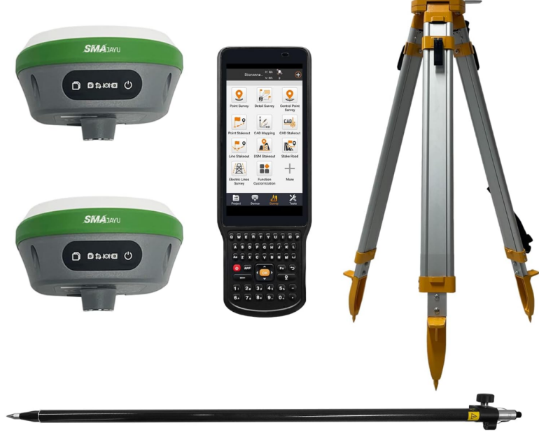
Enter the SMA26 GNSS Surveying System
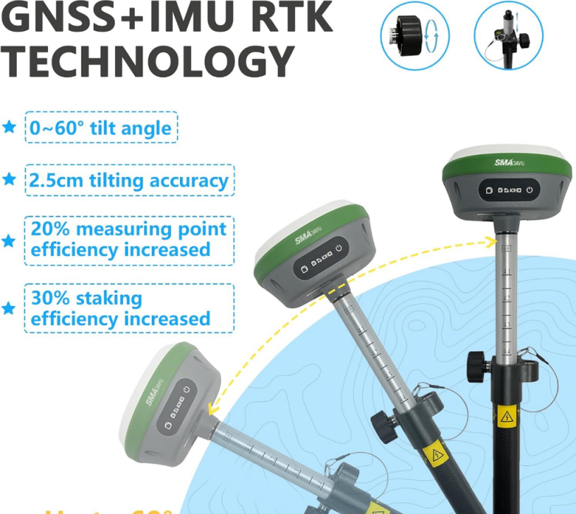
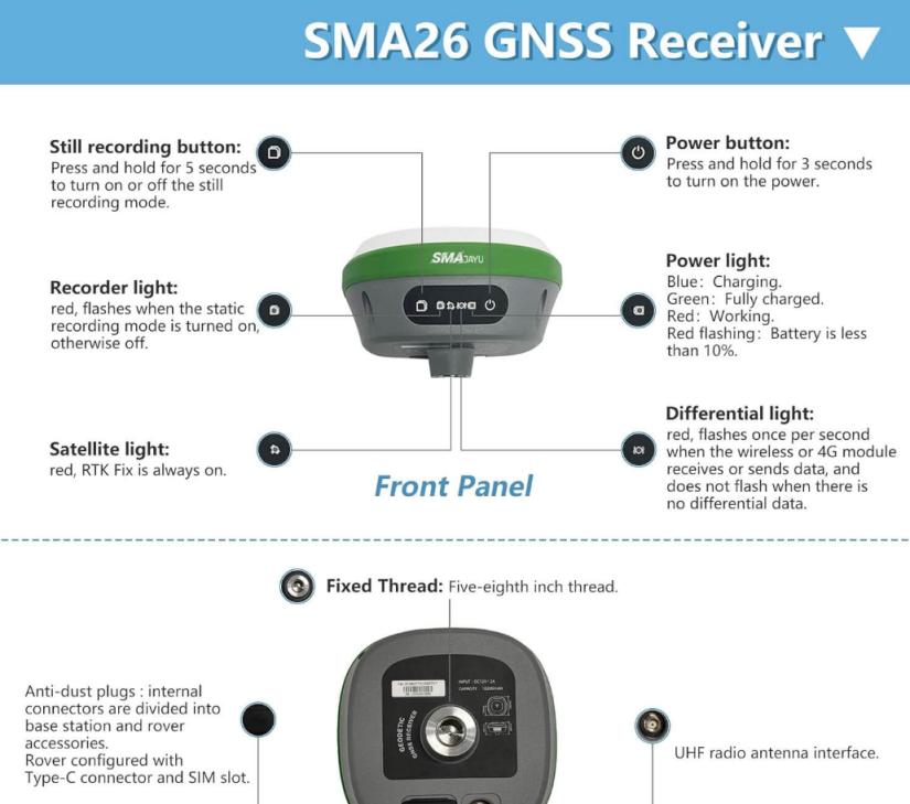
To tackle these challenges, modern surveying systems like the SMA26 GNSS receiver provide a highly efficient solution. The SMA26 GNSS system is a multifunctional and intelligent receiver with a built-in GNSS full-frequency antenna, high-precision positioning board, and wireless capabilities that enable it to perform in the most complex environments.
Why the SMA26 Stands Out
High-Precision Positioning:
The SMA26 GNSS receiver offers high-precision positioning, making it an essential tool for land engineers and surveyors. It can receive satellite signals from multiple constellations, including GPS and Beidou-3, ensuring that it can track over 40 satellites. This capability allows for accurate positioning in areas where traditional surveying tools might fail.
Long Battery Life for Remote Surveys:
One of the key advantages of the SMA26 is its built-in battery with a capacity of 10,200 mAh, allowing over 14 hours of continuous use. This feature is particularly useful for surveyors working in remote or difficult-to-access areas, ensuring long-term operation without the need for frequent recharging.
Wireless Communication:
Equipped with UHF wireless technology, the SMA26 system allows for smooth communication between the mobile station and base station. It also uses the CSS (LoRa) protocol, ensuring stable and efficient data transmission over long distances. This is crucial for large-scale land surveying projects where accurate data needs to be transmitted in real time.
Versatile Applications Across Industries
The versatility of the SMA26 GNSS receiver makes it suitable for a wide range of industries beyond construction, such as precision agriculture, geographic information systems (GIS), and mining. Its ability to deliver pinpoint accuracy ensures that Land Engineering & Surveying are done right the first time, no matter the project’s complexity.
Key Benefits of Using the SMA26 for Surveying
Reduced Surveying Time
The SMA26’s intelligent system simplifies the process of surveying by providing accurate measurements in less time than traditional methods. Whether used in a dense urban environment or a rural construction site, this system reduces the amount of time surveyors spend gathering and analyzing data, allowing projects to move forward more efficiently.
Enhanced Accuracy in Complex Environments
With its ability to track multiple satellite signals and search for over 40 satellites simultaneously, the SMA26 guarantees accuracy in complex environments. Whether dealing with forested areas, mountainous terrain, or congested urban zones, the system delivers the precise data that land engineers need to develop informed construction plans.
Durability in Harsh Conditions
Surveyors often work in harsh outdoor environments, and the SMA26 is built to withstand these conditions. Its robust design, coupled with long battery life, ensures it performs reliably in challenging weather or rough terrain, making it an indispensable tool for long-term projects.
Surveying for the Future: What Comes Next?
The Growth of GNSS Technology
As Global Navigation Satellite Systems (GNSS) technology continues to advance, surveyors and land engineers are witnessing an evolution in how they conduct their work. GNSS receivers like the SMA26 represent the future of land surveying, offering greater accuracy, efficiency, and reliability than ever before.
Automation and AI Integration
The integration of automation and AI into land surveying systems is another exciting development. Intelligent systems like the SMA26 already feature web-based platforms for remote management and device self-testing. As these technologies develop, the role of human surveyors may shift to more analytical and supervisory functions. Rely on machines to handle repetitive tasks.
Conclusion
Land Engineering & Surveying are critical to the success of construction projects. Without precise measurements and thorough planning, infrastructure projects would face serious risks, from misaligned buildings to unstable foundations. With advanced tools like the SMA26 GNSS receiver. Surveyors can overcome the challenges of difficult terrain, time constraints and environmental factors. Ensuring projects are completed on time and with unmatched accuracy.
The SMA26 GNSS receiver from SMAJAYU is more than just a tool; it’s a solution for the future of land engineering and surveying. Its versatility, precision, and robust design make it an indispensable asset across industries, from construction to agriculture. As technology continues to advance, tools like the SMA26 will only become more essential, ensuring that land engineering remains at the cutting edge of innovation.
Ready to invest in advanced land surveying technology? Consider the SMA26 RTK GNSS receiver for your next project and experience the future of surveying today.
