

Why Accurate Land Surveying Instruments Are Vital for Construction Projects
Imagine trying to build a skyscraper on shaky ground or lay down railway tracks without knowing the precise terrain dimensions. Sounds impossible, right? This is exactly why accurate land surveying equipment is crucial for construction projects. Surveyors rely on precise measurements to map out land contours, set boundaries, and provide the groundwork for any structure or infrastructure project.
Without accurate surveying equipment, errors could occur, leading to costly construction mistakes or even legal issues. Precision is key because every inch counts in the world of construction, whether it’s marking property lines or ensuring a building’s foundation is level. Advanced tools like GPS receivers, total stations, and RTK systems provide the accuracy necessary to avoid these pitfalls.
How to Calibrate Your Land Surveying Equipment for Optimal Performance
Precision equipment requires regular calibration to maintain its accuracy. Whether you're using a basic leveling instrument or an advanced RTK GPS system like the R26 V2 RTK GPS Surveying System, calibration ensures that your tools work at peak performance.
Step 1: Understanding Calibration
Calibration is a necessary process that adjusts your surveying equipment to match a known reference standard. This helps eliminate inaccuracies that may accumulate over time due to environmental conditions, wear, or transport damage. For complex instruments like the R26 V2 RTK GPS, calibration is vital to maintain centimeter-level accuracy in measurements. Surveyors typically calibrate before every major project or when they suspect the device’s accuracy has been compromised.
Step 2: Step-by-Step Calibration for RTK Systems
For a product like the R26 V2 RTK GPS Surveying System, here’s how you can calibrate it:
1. Connect your handheld collector to one of the R26 receivers via Bluetooth and set it up as the base station.
2. Wait for three minutes for the connection to stabilize—this waiting period is essential to ensure the system properly initializes.
3. Disconnect the base station from the collector and then connect the collector to the other R26 unit, which acts as the rover.
4. Ensure both the rover and base are set to the same wireless protocol and channel. Once “fixed” appears, you can proceed with the surveying job.
Step 3: Benefits of Proper Calibration
Properly calibrated equipment like the R26 V2 ensures your measurements are accurate down to 0.5–2.5 cm. This level of precision is essential when working on projects like road layouts, land subdivisions, and geodetic surveys. Investing a few minutes in calibration can save hours of work and ensure that your entire project proceeds without complications.
The Importance of Surveying Tripods: Stability for Accurate Results
When surveying, every movement or vibration can affect the accuracy of your results. That's why the quality and stability of your tripod matter just as much as the measuring instruments you're using. A stable tripod provides a secure foundation for equipment like total stations, levels, and GPS receivers, ensuring minimal movement during measurements.
Why Stability Matters
Surveying tripods serve as the foundation for most land surveying equipment. Even a slight shift can affect the accuracy of the readings, especially when working over long distances. For example, the R26 V2 RTK GPS Rover comes with a high-quality tripod to minimize vibrations and movement. A tripod that doesn’t offer proper stability can lead to misalignment, forcing you to redo measurements and wasting precious time.
Features to Look For in Surveying Tripods
When choosing a tripod, it’s essential to look for:
Durability: Sturdy materials like aluminum or carbon fiber ensure that the tripod can withstand the rigors of a construction site.
Ease of Use: The tripod should be easy to set up, allowing for quick adjustments on-site.
Portability: You’ll need a tripod that’s easy to transport, especially when moving across rough terrains.
Maximizing Tripod Efficiency
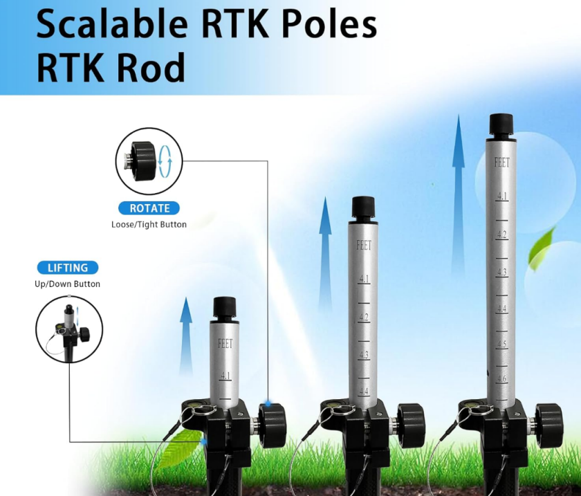
Surveyors often underestimate the role of a tripod in ensuring accurate results. A well-designed tripod should allow for micro-adjustments and should come equipped with leveling features. For example, the tripod included with the R26 V2 RTK system offers high stability, contributing to its centimeter-level accuracy.
Portable Surveying Equipment: Tools for Surveying on the Go
The landscape of surveying is changing rapidly. Traditional bulky equipment is being replaced with portable tools that allow surveyors to perform their jobs more efficiently, even in challenging environments. Today, surveyors need equipment that’s not only accurate but also portable and easy to set up.
The Advantages of Portable Surveying Equipment
Portable surveying equipment like the R26 V2 RTK GPS Rover offers several key advantages:
Ease of Transport: Compact, lightweight equipment is easier to carry, reducing strain and allowing surveyors to cover more ground in less time.
Quick Setup: Tools like the R26 can be assembled and disassembled quickly, ensuring minimal downtime between surveying tasks.
Versatility: Portable equipment is ideal for use in remote or hard-to-reach areas, where traditional tools may be difficult to deploy.
Ideal Applications for Portable Equipment
Portable surveying equipment excels in a variety of situations, including:
Rural or Mountainous Terrain: When surveying in areas that are difficult to access, having lightweight, mobile equipment is essential.
Construction Sites: On busy construction sites, surveyors need tools that can be quickly moved from one area to another without disrupting ongoing work.
Urban Planning: Compact equipment is a great solution for urban environments where space is often limited.
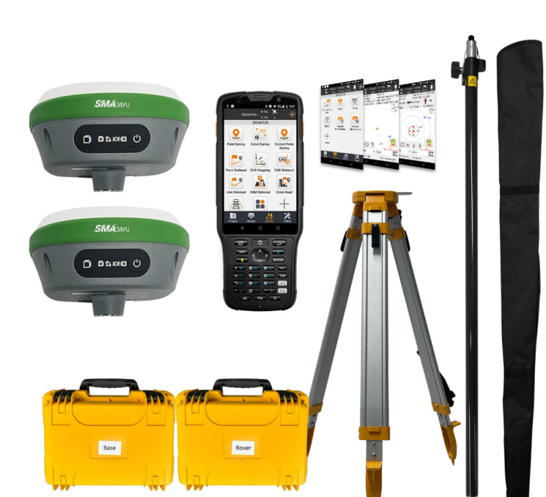
R26 V2 RTK GPS Rover: A Game-Changer
The R26 V2 RTK GPS system combines portability with high accuracy. With its lightweight design, integrated software, and adaptable poles, the system is perfect for surveyors on the move. It is built to withstand harsh environments, providing reliable results even in the most challenging conditions.
Eco-Friendly Surveying: Sustainable Technologies in Surveying Equipment
Sustainability is becoming increasingly important in every industry, including land surveying. More companies are now prioritizing eco-friendly practices, and that includes using sustainable surveying technologies that minimize environmental impact.
Why Eco-Friendly Surveying Matters
In an era of environmental awareness, it's vital for industries like construction and land development to adopt sustainable methods. Surveying is no exception. With equipment like the R26 V2 RTK GPS Surveying System, which is designed for long-term use, surveyors can reduce their environmental footprint by investing in durable, energy-efficient tools.
Sustainable Surveying Technologies
Modern surveying equipment includes energy-efficient features like:
Low Power Consumption: Many systems, including the R26 V2, are designed to operate on minimal power, reducing the need for frequent battery changes.
Durable Materials: Using long-lasting materials means fewer replacements, which in turn reduces waste.
Eco-Friendly Production: Manufacturers like SMAJAYU are embracing greener production methods to create equipment that is more sustainable.
The Future of Eco-Friendly Surveying
As technology evolves, we can expect more innovations in eco-friendly surveying equipment. The R26 V2 RTK GPS system is a perfect example, providing long-lasting durability, reduced power consumption, and easy software updates, all while maintaining high levels of accuracy and reliability.
The Solution for Wholesalers: R26 V2 RTK GPS Surveying System
For wholesalers in the land surveying equipment market, the R26 V2 RTK GPS Rover and Base Station package offers a solution that meets the needs of today’s professional surveyors. With a competitive price of $2,971.00, this comprehensive system provides everything a surveyor needs, from accuracy to portability and sustainability.
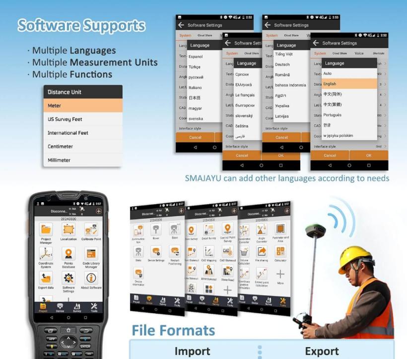
The R26 V2 RTK GPS System includes two GNSS receivers, a handheld collector, tripod, poles, and all necessary accessories. It’s a versatile system that supports GPS, GLONASS, and Galileo, ensuring compatibility with global navigation systems. Its durable design and easy-to-use features make it the perfect investment for surveying professionals looking for high-quality, long-lasting equipment.
Conclusion
In conclusion, the R26 V2 RTK GPS system from SMAJAYU offers wholesalers a top-tier product that will meet the demanding needs of their customers. Accurate, portable, and eco-friendly, it’s the ideal choice for construction projects, urban planning, and environmental surveys alike.
