

The R26 v2 +POLE by SMAJAYU is an advanced land surveying GPS system designed to meet the highest standards of precision and efficiency. Featuring RTK GNSS technology with 1408 channels and 1cm accuracy, it supports multiple satellite constellations, including GPS, GLONASS, and Galileo. The system is user-friendly with a straightforward setup process, durable construction, and robust software support, making it ideal for diverse surveying applications. SMAJAYU ensures reliable performance and comprehensive technical support for seamless operation in the field.
What is Land Surveying GPS?
Overview of Land Surveying GPS
Land surveying GPS technology has revolutionized the way surveyors measure and map the Earth's surface. By utilizing satellites and receivers, this technology provides highly accurate positioning data, essential for a variety of applications such as construction, geodetic surveys, and layout planning. GPS systems have become indispensable tools for surveyors, offering precision, efficiency, and reliability in their work.
Key Components of Land Surveying GPS
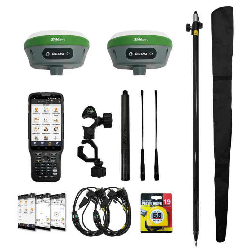
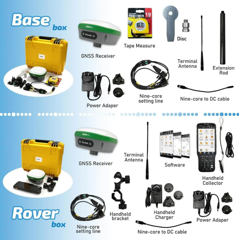
A typical land surveying GPS system consists of several key components: a base station, a rover, and a collector with specialized surveying software. The base station acts as a reference point, while the rover moves across the survey area to collect data. The collector processes this data to produce accurate measurements and maps.
Importance of Precision in Land Surveying
Precision is critical in land surveying, as even minor errors can lead to significant problems in construction and engineering projects. High-accuracy GPS systems, such as those using Real-Time Kinematic (RTK) technology, can achieve centimeter-level precision, making them invaluable for professionals in the field.
What is the R26 v2 +POLE for Land Surveying GPS?
Introducing the R26 v2 +POLE
The R26 v2 +POLE is an advanced RTK GNSS surveying system designed to meet the demanding needs of modern land surveyors. This system includes the R26 rover and base station, along with a handheld collector equipped with professional surveying software. Its capabilities extend beyond traditional GPS, incorporating GNSS (Global Navigation Satellite System) for enhanced accuracy and reliability.
Technical Specifications
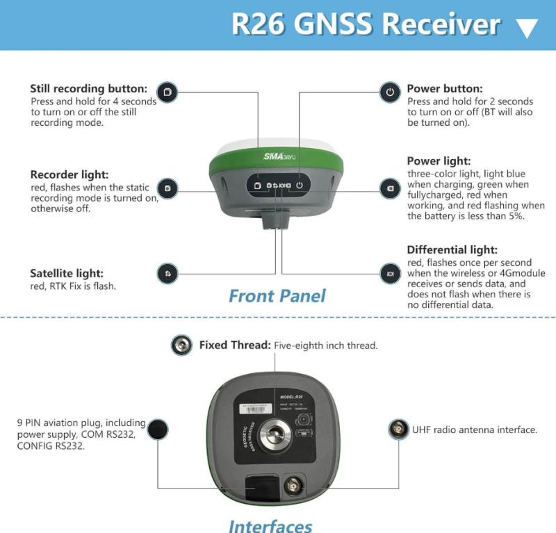
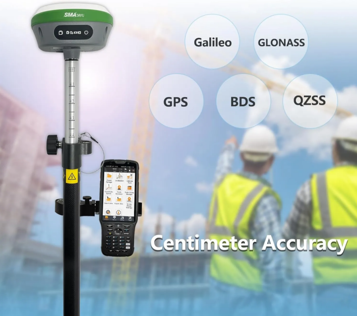
The R26 v2 +POLE boasts impressive technical specifications, including NOAA certification, 1408 channels, and 1cm accuracy. The system supports multiple GNSS constellations such as GPS, GLONASS, and Galileo, ensuring robust performance in various environments. The included pole features double scales in meters and feet, providing flexibility for different measurement preferences.
Competitive Advantages in the Market
In a fiercely competitive market, the R26 v2 +POLE stands out due to its combination of high precision, advanced features, and user-friendly design. The integration of inertial measurement units (IMU), built-in Bluetooth and wireless modules, and comprehensive software support gives it a significant edge over other surveying systems.
How to Use the R26 v2 +POLE for Land Surveying GPS
Step-by-Step Setup Process
Using the R26 v2 +POLE involves a straightforward setup process. First, the collector is connected to one R26 unit via Bluetooth to set it as the base station. After waiting for three minutes to ensure a stable connection, the collector is then connected to the other R26 unit, which acts as the rover. Both units must be set to the same wireless protocol "CCS" and channel until a fixed connection is established. Once this is done, the surveyor can proceed with parameter settings and begin the surveying job.
Ensuring Accurate Data Collection
To ensure the highest accuracy, it is crucial to follow the setup process meticulously. The base station provides a fixed reference point, while the rover collects data across the survey area. The R26 v2 +POLE's RTK technology ensures that measurements are precise and reliable, essential for producing accurate maps and plans.
Utilizing the Surveying Software
The R26 v2 +POLE comes with professional surveying software pre-installed on the handheld collector. This software is permanently valid, with updates available online to keep it current. The software offers comprehensive tools for data collection, processing, and analysis, making it a powerful asset for surveyors.
The Important Role of the R26 v2 +POLE for Land Surveying GPS
Enhancing Surveying Efficiency
The R26 v2 +POLE significantly enhances the efficiency of surveying tasks. Its high-precision measurements reduce the need for repeated surveys, saving time and resources. The system's user-friendly design and integrated modules make it easy to operate, even in challenging environments.
Versatility in Various Applications
The R26 v2 +POLE is versatile enough to be used in a wide range of surveying and engineering applications. Whether it's for construction projects, geographic information systems (GIS), or mine surveying, this system can adapt to different needs and provide reliable results. Its ability to operate in complex and harsh environments further underscores its utility.
Long-Term Reliability and Support
Durability and long-term reliability are key features of the R26 v2 +POLE. The equipment is built to withstand the rigors of fieldwork, with sturdy construction and a long service life. Additionally, the system comes with robust technical support from the supplier, SMAJAYU. Users can access support through email, online resources, and instructional videos, ensuring they can fully utilize the equipment's capabilities.
Conclusion
In conclusion, the R26 v2 +POLE stands out as a top-tier choice in the competitive market of land surveying GPS systems. Its high precision, advanced features, and ease of use provide surveyors with the tools they need to perform their jobs efficiently and accurately. The system's versatility and reliability make it suitable for a wide range of applications, ensuring it can meet the demands of modern surveying projects.
As technology continues to advance, the capabilities of land surveying GPS systems like the R26 v2 +POLE are likely to expand further. Innovations in GNSS, RTK, and software development will continue to enhance the accuracy and efficiency of these systems, providing even greater value to surveyors. By staying at the forefront of these developments, systems like the R26 v2 +POLE will remain essential tools in the field of land surveying.
For surveyors seeking a competitive edge in their work, the R26 v2 +POLE offers a compelling solution. Its combination of cutting-edge technology, user-friendly design, and robust support ensures that it can meet the highest standards of precision and reliability. As a product of SMAJAYU, the R26 v2 +POLE exemplifies the innovation and quality that define the best in land surveying GPS technology.
