

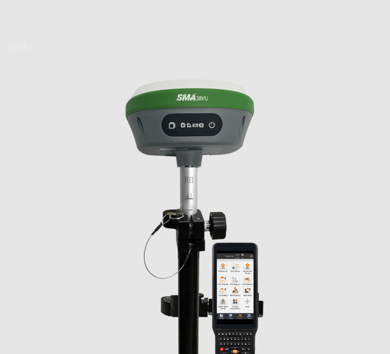
Imagine arriving at a remote site, fully prepared to initiate a complex land survey. The terrain is rugged, presenting numerous obstacles, and the success of your project depends entirely on precise data collection. However, just as you're about to begin, your equipment starts to falter, unable to produce the accurate measurements you need. This unfortunate delay underscores the critical importance of choosing the right land surveying tool. What distinguishes an excellent land surveyor tool from the rest? In this post, we'll delve into the essential characteristics to consider, using the SMA26 RTK Rover as a prime example to illustrate how state-of-the-art tools can significantly enhance the precision, efficiency, and dependability of your surveying work.
Precision and Accuracy: The Cornerstone of Surveying
For any land surveyor, the importance of precision cannot be overstated—it forms the very backbone of their work. When it comes to selecting a surveying tool, the ability to deliver pinpoint accuracy should be the primary consideration. One tool that excels in this domain is the SMA26 RTK Rover, renowned for its high-level precision, ensuring measurements that are accurate down to the centimeter.
GNSS Full-Frequency Antenna
The SMA26 RTK Rover comes equipped with an integrated GNSS full-frequency antenna, a feature that significantly improves the reception of signals across numerous satellite constellations. This multi-constellation capability is crucial, as it allows the device to track signals from GPS, GLONASS, Galileo, and Beidou. In environments where signal obstruction is common—such as dense forests or urban landscapes with towering structures—this feature guarantees accurate data collection.
High-Precision Positioning Board
In the world of surveying, professionals rely on tools that can provide rapid, precise positioning data under a wide range of external conditions. Thanks to the high-precision positioning board housed within the SMA26, this tool excels in maintaining accuracy across various applications, whether you're engaged in geodetic surveys, mapping projects, or even mechanical control tasks.
IMU and Real-Time Kinematics (RTK)
Precision is further elevated through the integration of Inertial Measurement Units (IMUs) and Real-Time Kinematics (RTK) technology. While IMUs work to correct any slight positional shifts, RTK ensures that positioning remains sharp and precise, even when conditions are less than ideal. This combination of technologies makes the SMA26 a robust choice for delivering consistently reliable and highly accurate data in any scenario.
Battery Life: Built for Long and Challenging Days
A long-lasting battery is not just a convenience; it’s an absolute necessity for land surveyors who often work in remote locations for extended periods. A tool that drains its battery mid-way through a job can lead to significant downtime and frustration, impacting productivity.
High Capacity Battery
The SMA26 RTK Rover offers a robust built-in 10200mAh battery, capable of powering the device for over 14 hours of continuous operation. This feature is particularly valuable for surveyors working in locations where access to power is limited or non-existent, such as construction sites, vast rural landscapes, or mountainous regions. With such extended battery life, surveyors can confidently complete their tasks without the looming concern of their equipment shutting down prematurely.
Designed for Harsh Environments
Extended battery life is about more than just the ability to work longer hours; it also speaks to reliability under extreme conditions. Whether you're surveying in scorching heat, freezing cold, or rugged terrain, the SMA26’s battery has the capacity to withstand the rigors of harsh environments, ensuring uninterrupted performance.
Fast Charging Capabilities
In addition to its impressive battery life, the SMA26 also features fast charging capabilities, reducing downtime between uses. Should the device begin to run low on power, surveyors can quickly recharge it during short breaks, allowing them to resume their work without significant delays.
Connectivity and Signal Reception: Seamless Communication in Any Setting
Surveying often takes professionals to remote or complex environments, where maintaining strong signal reception can be challenging. Without reliable connectivity, the flow of real-time data can be disrupted, resulting in costly delays.

UHF Wireless and 4G Connectivity
The SMA26 RTK Rover includes built-in UHF wireless technology, allowing the device to automatically switch between functioning as a mobile station or base station. This capability offers increased flexibility, enabling surveyors to adapt to various field conditions. Additionally, the addition of 4G connectivity facilitates real-time data transfer. Enables field workers and office teams to communicate seamlessly no matter where they are.
NebulasIV Signal Tracking System
Effective signal tracking is critical for ensuring accurate survey results. The SMA26’s NebulasIV system tracks up to 40+ satellites simultaneously, allowing it to maintain reliable signal reception even in environments where interference is likely, such as heavily forested areas or locations with tall structures. This robust tracking ability guarantees accuracy, even in the most complex environments.
CSS (LoRa) Protocol
To further enhance connectivity, the SMA26 utilizes the CSS (LoRa) wireless communication protocol, which supports long-range communication even in areas where cellular or Wi-Fi signals may be weak or non-existent. This feature allows surveyors to work across vast distances without the fear of losing connectivity or sacrificing data quality.
Ease of Use: Simplifying Operations and Transport
While accuracy and reliability are paramount, surveyors also require tools that are easy to operate and portable. Tools that are cumbersome or require extensive training can slow down projects and hinder productivity.
Compact and Lightweight Design
The SMA26 has been designed with portability in mind. Its compact and lightweight construction allows surveyors to easily transport the device between job sites. No heavy transport equipment is required. Whether you're climbing mountains or traversing urban construction zones. The SMA26 are both light enough to not be a burden.
Embedded Intelligent System
Further enhancing its ease of use, the SMA26 features an intelligent embedded system that includes a voice assistant, a web-based platform (WEBUI), and a self-test function. These user-friendly features make operating the device intuitive, streamlining workflows, and reducing the time required for setup and troubleshooting. Surveyors can easily manage the device through a browser, access real-time updates, and even perform self-diagnostics to ensure everything is functioning correctly.
Clear Instructional Interface
The SMA26’s user-friendly interface is designed to be straightforward, ensuring that surveyors can set up the device quickly and without hassle. When setting up a new SMA26, users can simply press the power button to activate it. If the battery is low, recharging is as simple as connecting the included adapter. The clarity of the interface minimizes the learning curve, making the tool accessible even to those new to surveying technology.
Versatility and Multi-Functionality: Adapting to a Range of Surveying Applications
A truly great land surveyor tool should be adaptable, capable of performing a wide variety of tasks across different industries. The versatility of a tool can be the difference between investing in a one-size-fits-all solution and having to purchase multiple specialized devices.

Multi-Functional GNSS Receiver
The SMA26’s ability to function as both a mobile station and a base station illustrates its versatility. This functionality makes it an indispensable tool for professionals working in construction, geodetic surveying, precision agriculture, and even drone-based aerial surveys. Its adaptability allows surveyors to take on a broad range of tasks without needing to switch equipment.
Support for Various Applications
Beyond its role in traditional surveying, the SMA26 can also be used in industries such as mechanical control, mine surveying, water surveying, and aerial photography. Its capability to operate effectively in such a diverse array of applications underscores its value as a multi-functional tool.
Surveying Software Integration
The SMA26 GNSS Surveying System integrates surveying software that allows users to collect, manage, and analyze data efficiently. The system features dual RTK GNSS receivers that provide high-precision measurements and reference positions in real time. Adding another layer of precision to its already versatile performance.
Conclusion: Why the SMA26 RTK Rover is a Superior Land Surveyor Tool
In conclusion, the SMA26 RTK Rover exemplifies what makes an outstanding land surveyor tool. The SMA26 offers unrivalled accuracy, robust battery life, reliable connectivity, ease of use and incredible versatility. It meets the demanding needs of modern surveyors, ensuring the job is completed with the highest precision and efficiency. Whether you are a seasoned professional or new to the field, the SMA26 offers all the essential features. Helping you succeed in the most challenging environments. With SMAJAYU’s commitment to quality, the SMA26 RTK Rover is an investment in accuracy, reliability, and operational excellence—qualities that every great land surveyor tool should have.
