

The Need for Precision
Accuracy is very important in civil engineering. Every small mistake can cause big problems. If measurements are wrong, buildings may not be safe. Roads may not last long. Projects may take more time and cost more money.
So, how can engineers make sure their work is precise? They need the right tools. One of the best tools today is RTK GPS. This technology helps engineers measure land with great accuracy. It gives real-time data and reduces errors.

Technology is changing how engineers work. In the past, measuring land took a long time. Now, RTK GPS makes it faster and easier. But how does it work? And why is it better than other tools?
Understanding RTK GPS Technology
What is RTK GPS?
RTK GPS stands for Real-Time Kinematic GPS. It is a technology that improves the accuracy of GPS positioning. Normal GPS can have errors of several meters. RTK GPS reduces these errors to just a few centimeters. It does this by using a base station and a rover. The base station stays in a fixed position. It sends correction signals to the rover, which moves around and collects data.
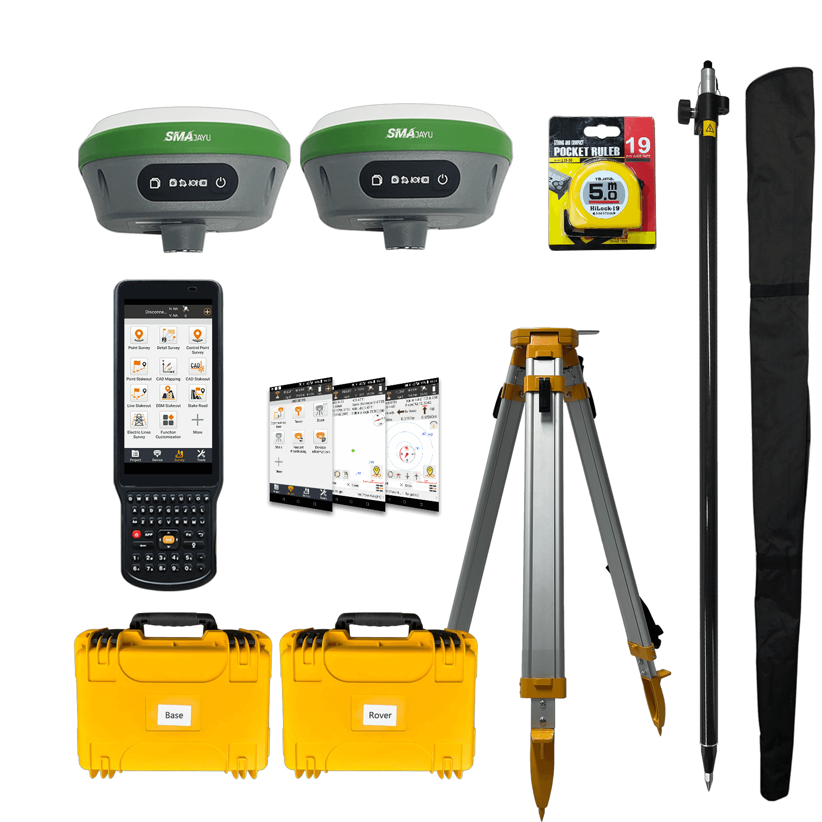
At SMAJAYU, we provide high-precision GNSS solutions for many industries. These include agriculture, surveying, and engineering. Our technology improves efficiency and productivity. One of our top products is the SMA26 V2 RTK GPS Rover. It includes an RTK base station, a permanent software system, and an IMU tilt surveying feature. This device is designed for accurate and reliable land measurements.
Why is RTK GPS Important?
RTK GPS is an advanced tool in surveying. It allows engineers and surveyors to collect data instantly. Unlike older methods, it does not require extra processing after the survey is complete. This means engineers can check their accuracy in real time. If there is an error, they can correct it immediately.
Traditional surveys often require revisits to fix mistakes. RTK GPS removes this problem. It improves efficiency, saves time, and reduces costs. It can also be used for both level 3 and level 4 surveys. This makes it a great option for a wide range of civil engineering projects.
RTK GPS in Different Fields
The SMA26 RTK GNSS receiver is suitable for many applications. It is widely used in:
- Surveying and mapping engineering
- Geographic information systems (GIS)
- Mine surveying
- Construction and infrastructure development
This technology works well in complex environments. It supports multiple satellite systems, including GPS, GLONASS, and Galileo. This ensures accurate data collection even in difficult locations.
Accuracy and Real-Time Performance
How Accurate is RTK GPS?
Accuracy is one of the biggest advantages of RTK GPS. Standard GPS systems can have positioning errors of up to 5-10 meters. In contrast, RTK GPS provides centimeter-level accuracy. For example, the SMA26 RTK GNSS receiver offers:
- 0.5-2.5 cm accuracy
- A 5-8 km working range
- 30-60 degree tilt compensation
This level of precision is critical in civil engineering. It ensures that buildings, roads, and other structures are built correctly.
Real-Time Corrections for Better Efficiency
RTK GPS systems provide corrections in real time. The rover and base station communicate instantly. This allows surveyors to get accurate data without delays. The system supports multiple frequency bands, including:
- BDS (B1I/B2I/B3I)
- GPS (L1C/A, L2C, L5)
- GLONASS (G1, G2, G3)
- Galileo (E1, E5a, E5b, E6)
- QZSS (L1, L2, L5)
These features allow RTK GPS to function in different conditions. However, the system has limitations. The base station must be within 5 kilometers of the rover for maximum accuracy. If the distance increases, the accuracy may decrease slightly.
Satellite Availability and Survey Planning
RTK GPS depends on satellite signals. The number of available satellites affects performance. Some days, there may be fewer satellites in the sky. This can impact survey accuracy.
Surveyors may need to adjust their schedules based on satellite availability. This may seem inconvenient, but it actually improves work efficiency. Proper planning ensures the best possible accuracy.
RTK GPS is a powerful tool for civil engineers. It saves time, reduces errors, and improves accuracy. With the right setup, it can make surveying faster and more reliable.

Cost and Time Efficiency in Construction
Faster Surveying and Reduced Manpower Costs
Surveying takes time and effort. Traditional methods need more workers and take longer to complete. SMA26 RTK makes the process faster and more efficient. It tracks signals from satellites with high precision. This allows surveyors to collect data quickly.
SMA26 RTK reduces the need for extra manpower. A single person can handle a survey that usually requires a team. This lowers labor costs. It also means projects can move forward without delays. Faster surveys help engineers start construction sooner.
Minimizing Errors and Avoiding Costly Rework
Mistakes in surveying can be expensive. Errors can lead to design flaws, which require costly corrections. SMA26 RTK helps prevent this. It provides accurate data in real time. If there is an issue, engineers can fix it on the spot.
The system includes a built-in UHF wireless module. This allows automatic switching between the mobile station and base station. Surveyors do not need to stop and adjust settings manually. This feature helps maintain accuracy and saves time.
Long Battery Life for Continuous Operation
Construction projects take place in tough conditions. Surveyors often work for long hours in remote areas. SMA26 RTK devices are designed for such environments. They have built-in batteries with a 10,200mAh capacity. This allows them to run for over 14 hours without needing a recharge.
A long battery life ensures uninterrupted work. Engineers can complete tasks without worrying about power loss. This makes RTK GPS reliable for large projects.
Key Applications in Civil Engineering
Land Surveying and Topographic Mapping
SMA26 RTK is widely used in land surveying. It helps engineers create accurate maps and topographic models. These models are important for planning construction projects. They show land elevations, boundaries, and natural features. Accurate maps prevent errors in site selection. They help engineers design buildings and roads that fit the terrain. SMA26 RTK ensures that measurements are correct from the start.
Road Construction, Bridgework, and Utility Projects
Infrastructure projects need precise measurements. SMA26 RTK helps with road construction, bridge building, and utility installations. Engineers use it to mark exact locations for structures. For road construction, SMA26 RTK ensures roads are straight and at the correct elevation. For bridges, it helps position supports and foundations accurately. Utility companies use RTK GPS to lay pipes and cables in the right place. SMA26 RTK makes these projects more efficient. It reduces errors, saves time, and improves safety. This is why it is an essential tool in civil engineering today.
Overcoming Challenges with SMA26 RTK
Signal Obstructions and How to Solve Them
RTK GPS depends on strong satellite signals. Trees, buildings, and bad weather can block signals. This can reduce accuracy and cause delays. Surveyors must find open areas to get the best results.
The SMA26 RTK has 1,408 channels to track multiple satellites at once. It includes built-in Bluetooth, wireless connectivity, and storage. It also has an inertial navigation system. These features help it work better in areas with obstacles.
The system uses a base station and a rover to improve accuracy. The base stays in a fixed position and sends correction signals to the rover. This ensures precise measurements. The device is small, lightweight, and easy to carry. It also has low power consumption, which makes it reliable for long surveys.
Initial Investment vs. Long-Term Benefits
RTK GPS equipment can be expensive. However, it saves money in the long run. Traditional surveying takes more time and requires more workers. SMA26 RTK allows one person to complete a survey quickly. This reduces labor costs.
Mistakes in measurements can lead to expensive corrections. SMA26 RTK provides real-time data to prevent errors. This avoids costly rework. Over time, the savings from faster surveys and fewer mistakes make SMA26 RTK a smart investment.
How to Use SMA26 RTK
Step-by-Step Setup
Setting up SMA26 RTK is simple. Follow these steps:
- Connect the collector to one SMA26 device via Bluetooth. Set it as the base station. Wait 3 minutes for it to stabilize.
- Disconnect the collector from the base. Then, connect it to another SMA26 device. Set this as the rover.
- Set the same wireless protocol and channel on both devices. Use "CCS" protocol. Wait until the system is fixed and ready.
- Adjust parameters and start surveying.
Following these steps ensures accurate data collection.
Getting Technical Support
Users may need help with setup or troubleshooting. SMAJAYU provides technical support to ensure proper operation. Customers can:
- Check the PDF manual available online.
- Contact the seller's support team for assistance.
- Watch tutorial videos on the SMAJAYU YouTube channel.
With proper setup and support, SMA26 RTK works efficiently for all surveying needs.
Get Accurate Surveys Now with SMA26 RTK!
Need precise measurements for your project? SMA26 RTK delivers fast, reliable, and accurate surveying. Avoid errors, save time, and reduce costs. Easy to set up, lightweight, and built for tough conditions. Order now and improve your efficiency today! Contact SMAJAYU for expert support!
