

RTK GPS is an advanced technology that enhances the accuracy of infrastructure projects by providing precise location data. Industries such as construction, engineering, and surveying depend on it for reliable measurements. In these fields, even small errors can lead to costly delays and project failures.
Why is precision critical? Roads, bridges, and buildings must be built to last, and accurate measurements are essential for their strength and stability. That's why professionals trust RTK GPS - it enables them to work faster, smarter, and more efficiently.

SMAJAYU, backed by over 15 years of experience, is at the forefront of this innovation. With a dedicated team and a commitment to excellence, they continuously bring fresh ideas and reliable solutions to the industry.
What Is It
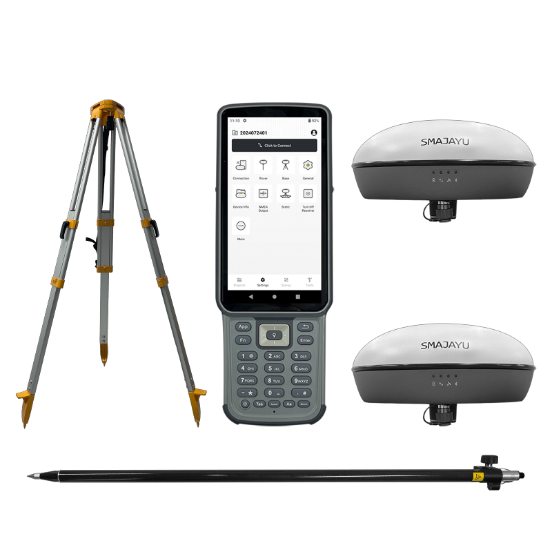
SMA20 RTK: A Versatile and Lightweight Receiver
SMA20 RTK is a small and easy-to-carry GNSS RTK receiver. It works well in different environments. It gives accurate position data fast. It works even in places where signals are weak. It can track signals from different satellites. This makes it reliable for many tasks. It is used in construction, surveying, and engineering.
IMU Technology for Easier Measurement
SMA20 RTK has an Inertial Measurement Unit (IMU). This helps users measure without leveling the bubble. Traditional tools need the bubble to be level. With IMU, this is not needed. It makes work faster and easier. Tilt surveys are more efficient. Users do not need to spend extra time adjusting. They can measure at different angles. This makes the device more flexible for different jobs.
Certified GNSS Antenna for Better Performance
SMA20 RTK has a GNSS antenna. It is registered with NOAA. This means it meets high standards. The certified antenna ensures better signal reception. It helps in getting accurate data. This improves the reliability of the receiver. It is trusted for professional use.
Why SMA20 RTK is Special
Multiple Modes for Different Needs
SMA20 RTK supports many positioning methods. It includes RTK, PPK, and PPP correction modes. It also allows static and Rinex logging. It has an internal UHF radio with a 900MHz frequency. It can connect to Network CORS stations. Users can work in static and basic modes at the same time. This makes it more versatile for different surveying needs.
High Accuracy for Precise Results
SMA20 RTK provides high accuracy. For RTK mode, horizontal accuracy is ±10mm. Vertical accuracy is ±18mm. When measuring with a tilt angle of 30°, the horizontal accuracy is 2.5cm. The device allows a maximum tilt of 60°. In static mode, horizontal accuracy is ±(2.5 mm + 0.5 ppm). Vertical accuracy is ±(5 mm + 0.5 ppm). For PPK mode, horizontal accuracy is 25mm. These precise measurements help in professional surveying tasks.
Advanced IMU for Reliable Tilt Surveying
SMA20 RTK has a built-in high-precision IMU. The IMU includes a gyroscope and an accelerometer. This improves tilt measurement. With GNSS and IMU working together, users can measure at any angle. Even at a tilt of 60°, accuracy remains within 3 cm. This makes surveying more flexible. Users can work in difficult conditions. They do not need to hold the receiver perfectly upright. This improves efficiency and saves time.
SMA20 RTK is designed for professionals. It combines advanced technology with ease of use. It helps users get precise results quickly. It is a powerful tool for modern infrastructure projects.
Transforming Infrastructure Projects with Precision
Applications in Road Construction, Bridges, and Urban Planning
Infrastructure projects need accurate data. Roads, bridges, and cities must be built with precision. Mistakes can cause delays and extra costs. SMAJAYU RTK is used in many fields. It helps civil engineers with planning and measuring. It is useful for topographic surveys. Surveyors rely on it to map land features correctly.
SMAJAYU RTK also supports infrastructure projects. It helps in designing and building roads and bridges. It is used in mining and quarrying. It helps workers measure land and track changes. It is also used for environmental monitoring. It collects data about land, water, and air. Utility companies use it for mapping. They track pipelines, power lines, and underground cables. It helps prevent damage during construction.
Reducing Errors, Rework, and Costs with SMA20 RTK
Errors slow down projects. If measurements are wrong, work must be redone. This wastes time and money. SMA20 RTK gives accurate results. It helps engineers and surveyors work faster. Workers can trust the data. This reduces mistakes.
Fewer errors mean less rework. This saves money. Projects finish on time. Companies avoid extra costs. SMA20 RTK helps teams stay on schedule. It makes projects more efficient.
Efficiency and Sustainability in Development
Faster Project Timelines with Precise Geolocation
Infrastructure projects take time. Delays increase costs. Fast and accurate tools help finish projects sooner. SMA20 RTK provides precise location data. It helps teams plan better. Workers know where to build. They avoid mistakes.
SMA20 RTK works in all conditions. It has a waterproof shell. It resists rain, dust, and extreme weather. It performs well in difficult environments. Workers do not have to stop when the weather is bad. This helps projects stay on track.
Minimizing Environmental Impact Through Optimized Planning
Bad planning harms the environment. Roads and buildings must be placed carefully. SMA20 RTK helps teams plan better. It collects data about land and nature. Engineers use this data to make smart choices. Accurate planning protects nature. It reduces damage to forests, rivers, and wildlife. It also prevents land waste. Projects use land efficiently. SMA20 RTK helps companies build responsibly.
Industry Adoption: Success Stories and Case Studies
Real-World Examples of SMA20 RTK in Action
Many industries use SMA20 RTK. Engineers use it to build roads and bridges. Surveyors use it to map cities. It helps mining companies track land changes. Environmental experts monitor forests and rivers with it. Utility companies also use it. They map underground pipes and cables. This prevents damage during construction. SMA20 RTK improves safety. It helps teams work with confidence.
How Companies and Governments Are Leveraging the Technology
Governments invest in accurate tools. They use SMA20 RTK for city planning. It helps in transportation projects. It supports smart city development. It improves traffic management. Companies also rely on SMA20 RTK. Construction firms use it for precision. It reduces waste. It helps them finish projects on time. Many industries trust SMA20 RTK. It makes work faster, safer, and more efficient.
Boost Efficiency with SMA20 RTK - Fast, Accurate, and Reliable
The SMA20 RTK enhances productivity with rapid, precise data collection. Designed to perform in tough environments, it remains reliable even in harsh weather. Its compact, portable design simplifies fieldwork, making measurements effortless.
This advanced tool saves time and money while minimizing errors. Ideal for road and bridge construction, land surveying, mining, mapping, and environmental monitoring, the SMA20 RTK is trusted across industries. It accelerates projects, improves accuracy, and makes work more efficient.
Upgrade your workflow-get the SMA20 RTK today and work smarter, faster, and with confidence.
