

In today’s rapidly evolving technology landscape, the field of land surveying is experiencing significant advancements. Among these, the satellite survey of land has emerged as a game-changer. At the forefront of this innovation is the R26 GNSS Receptor, a sophisticated tool designed to meet the rigorous demands of modern surveying. This blog explores the competitive advantages offered by the R26 GNSS Receptor in the fierce market of land surveying.
Understanding Satellite Survey of Land
What is Satellite Survey of Land?
Satellite survey of land, also known as GNSS (Global Navigation Satellite System) surveying, utilizes satellite signals to determine precise locations on Earth. This technology enables surveyors to achieve high accuracy in mapping and measuring land features, which is crucial for various applications such as construction, land development, and environmental studies.
Importance of Satellite Surveying
The importance of satellite surveying cannot be overstated. It provides unparalleled accuracy, efficiency, and reliability compared to traditional surveying methods. With the ability to cover large areas quickly and with high precision, satellite surveying is indispensable in projects requiring detailed topographic information.
Evolution of GNSS Technology
The evolution of GNSS technology has transformed land surveying practices. Modern GNSS systems like the R26 GNSS Receptor incorporate advanced features that enhance performance and usability, making them essential tools for professional surveyors.
The Essential Needs of Modern Land Surveying
High Accuracy and Precision
Modern land surveying demands high accuracy and precision to ensure the reliability of data. Surveyors need tools that can provide centimeter-level accuracy to map land features accurately. This precision is critical for applications such as construction, land development, and environmental studies, where even minor errors can lead to significant issues.
Efficiency and Speed
Efficiency and speed are crucial in land surveying, as projects often cover vast areas and tight schedules. Traditional surveying methods can be time-consuming and labor-intensive. Surveyors require advanced tools that can quickly gather accurate data, reducing the time and effort involved in the surveying process.
Versatility and Flexibility
The diverse nature of land surveying projects necessitates versatile and flexible tools. Surveyors encounter different terrains, weather conditions, and project requirements. Therefore, they need equipment that can adapt to various environments and provide consistent performance under different circumstances.
Introduction to R26 GNSS Receptor
What is R26 GNSS Receptor?
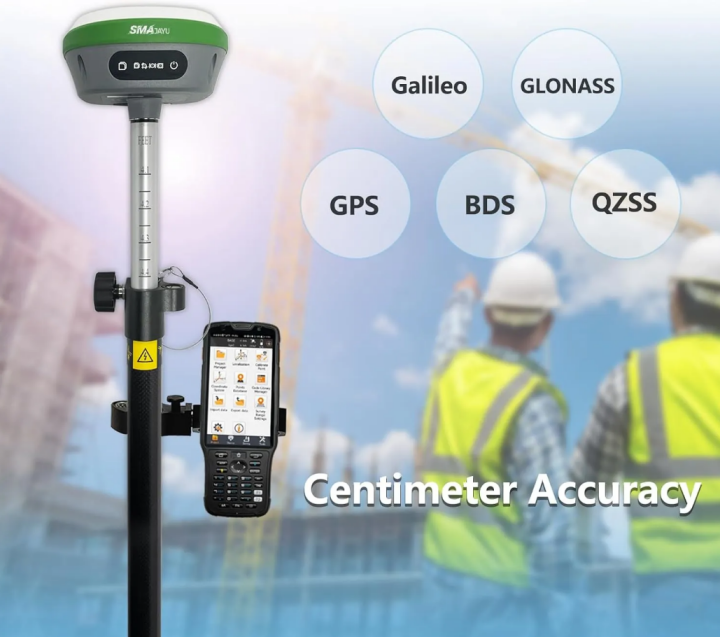
The R26 GNSS Receptor is a state-of-the-art device designed for high-precision land surveying. Manufactured by SMAJAYU, this receptor is equipped with cutting-edge technology to deliver accurate and reliable results for various surveying needs.
Key Features of R26 GNSS Receptor
The R26 GNSS Receptor boasts several key features:
Built-in Bluetooth, wireless, storage, positioning, inertial navigation, antenna, and other modules: These components provide comprehensive functionality to meet diverse measurement requirements.
Two operating modes: Users can switch between base station mode and rover mode depending on the specific needs of the survey.
Innovative design: The receptor includes an inertial module that offers automatic pole tilt compensation, ensuring accuracy even in challenging conditions.

Applications of R26 GNSS Receptor
This receptor is versatile and can be used in a range of applications, including:
1. Topographic surveys
2. Land surveys
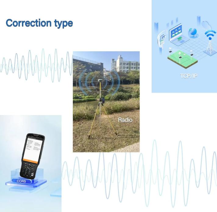
3. Correction by CORS (Continuously Operating Reference Stations)
4. Mobile base operations
5. TCP/IP communication for data transfer
Solutions Offered by the R26 GNSS Receptor
Addressing the Need for High Accuracy
The R26 GNSS Receptor delivers exceptional accuracy, making it ideal for precise land surveying tasks. Its integration of GNSS global corrections services via satellite and internet enables centimeter-level positioning accuracy. This high precision ensures reliable data for critical applications, reducing the risk of errors and rework.
Enhancing Efficiency and Speed
The compact and lightweight design of the R26 GNSS Receptor enhances efficiency and speed in land surveying. The receptor’s ability to quickly gather and process data significantly reduces the time required for surveys. Additionally, the included surveying software, which is permanently valid and pre-installed in the handheld device, streamlines the workflow, further increasing productivity.
Providing Versatility and Flexibility
The R26 GNSS Receptor’s dual operating modes and robust construction offer versatility and flexibility in various surveying conditions. Surveyors can switch between base station and rover modes as needed, adapting to different project requirements. The receptor’s built-in modules ensure reliable performance in diverse environments, from urban areas to remote locations.
How to Use R26 GNSS Receptor for Satellite Survey of Land
Setting Up the R26 GNSS Receptor
Setting up the R26 GNSS Receptor is straightforward. The compact design and lightweight nature make it easy to carry and operate. The GNSS receiver can access global corrections services via satellite and the internet, providing centimeter-level positioning accuracy.
Conducting Surveys with R26 GNSS Receptor
Surveyors can utilize the receptor for both static and RTK (Real-Time Kinematic) surveys. The R26 GNSS Receptor supports various correction types, including wireless, CORS, and TCP/IP, ensuring flexibility in different environments. The surveyor can easily import and export data in multiple formats, enhancing compatibility with other software and tools.
Data Management and Export
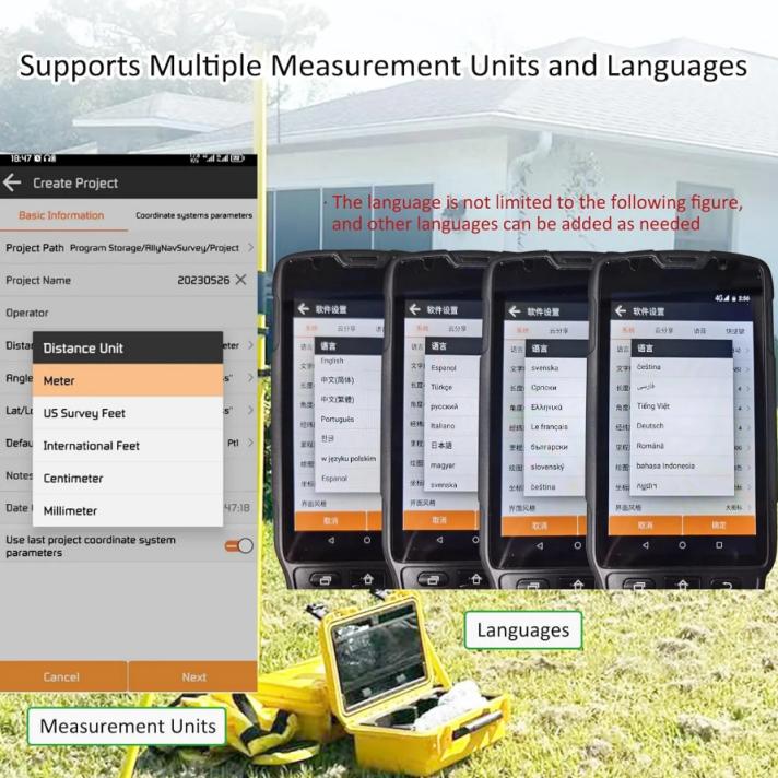
The receptor supports a wide range of file formats for importing and exporting data. Formats such as dat, txt, csv, dxf, shp, kml, kmz, and gpx are supported, allowing for seamless integration with existing workflows. Additionally, the device can convert text format files to RINEX format using the SMAJAYU convert tool, facilitating data sharing and analysis.
Meeting Surveying Needs with R26 GNSS Receptor
Accuracy and Precision
The R26 GNSS Receptor delivers exceptional accuracy and precision, which are critical for land surveying. The integration of the inertial module for automatic pole tilt compensation ensures that measurements remain accurate even when the receptor is not perfectly aligned.
Versatility and Flexibility
The receptor’s ability to switch between base station and rover modes provides versatility for different surveying tasks. This flexibility allows surveyors to adapt to various project requirements, whether they are conducting large-scale topographic surveys or detailed land boundary measurements.
Ease of Use and Portability
The compact and lightweight design of the R26 GNSS Receptor makes it highly portable and easy to use. Surveying software pre-installed in the handheld device is permanently valid, eliminating the need for frequent updates or additional purchases. This ease of use reduces training time and enhances productivity.
Competitive Advantage in the Market
Innovation and Technology
The R26 GNSS Receptor incorporates the latest technological innovations, setting it apart from competitors. Features like the inertial navigation module, automatic tilt compensation, and dual-mode operation ensure that surveyors have access to the best tools for their work.
Reliability and Support
SMAJAYU, the supplier of the R26 GNSS Receptor, is known for its reliable products and excellent customer support. The receptor is NOAA certified, guaranteeing its quality and performance. Surveyors can rely on SMAJAYU for technical assistance and updates, ensuring long-term satisfaction with their investment.
Cost-Effectiveness
While offering advanced features and high precision, the R26 GNSS Receptor remains cost-effective. Its all-in-one design reduces the need for additional equipment, and the included surveying software provides ongoing value without additional costs. This cost-effectiveness makes it an attractive option for surveyors looking to enhance their capabilities without breaking the bank.
Conclusion
In the competitive field of land surveying, the R26 GNSS Receptor stands out as a top choice for professionals seeking accuracy, reliability, and versatility. Its advanced features, ease of use, and cost-effectiveness provide significant advantages in meeting the diverse needs of modern surveying projects. As technology continues to evolve, tools like the R26 GNSS Receptor will remain at the forefront, driving efficiency and precision in land surveying.
