

Intelligent agriculture transforms modern farming by integrating advanced technologies to optimize crop cultivation and livestock management. Through the use of sensors, data analytics, and automated systems, farmers can enhance efficiency, making farming both more productive and sustainable. Technology aids in better managing water, soil, and pest control, reducing waste and boosting crop yields. Surveying engineers play a crucial role in this evolution by collecting vital data and delivering key insights that guide decision-making. Their expertise enables farmers to plan strategically and utilize resources more effectively. As technology advances, the role of surveying engineers will remain integral to the continued progress of agriculture.
The Role of a Surveying Engineer
Definition of Surveying Engineering
Surveying engineering is a branch of engineering that focuses on measuring and mapping the earth's surface. It helps professionals collect data that are necessary for construction, land development, and resource management. Surveying engineers use different tools and techniques to ensure measurements are accurate and reliable. Their work is important in many fields, including agriculture, construction, and land management.
Key Responsibilities of a Surveying Engineer in General
A surveying engineer has several key responsibilities. They must measure land, determine boundaries, and create accurate maps. They also prepare reports and plans for various projects. Surveying engineers often work with other professionals, such as architects and urban planners, to ensure that projects follow the proper guidelines. Their work involves using advanced tools, like GPS systems and drones, to collect data. They also interpret and analyze this data to help make informed decisions.
Transitioning into Intelligent Agriculture
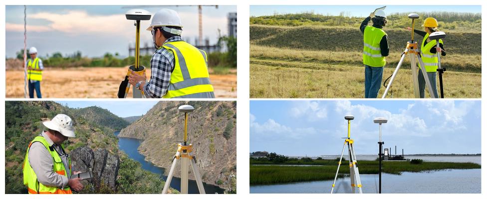
In recent years, surveying engineers have expanded their role into agriculture. They now apply their expertise to intelligent agriculture, which uses advanced technology to improve farming. Their knowledge of mapping, data collection, and analysis helps farmers make better decisions about land use and crop management. By using surveying techniques, engineers can provide accurate information about the land's condition. This information can guide farmers in using resources efficiently, leading to better crop yields and sustainable practices.

Application of Surveying in Intelligent Agriculture
Precision Mapping and Land Measurement
Surveying engineers play a key role in precision agriculture. They use their skills to map the land accurately. This helps farmers understand the layout of their fields. With precise maps, they can identify areas of the land that need attention. Accurate measurements also ensure that crops are planted in the best possible locations, improving productivity.
Data Collection and Analysis
Surveying engineers use Geographic Information Systems (GIS) and Global Positioning Systems (GPS) to collect data about agricultural land. GIS helps to organize and analyze data related to soil type, crop yield, and other factors. GPS provides precise location data, making it easier to track changes over time. These technologies enable engineers to assess the land's condition and give farmers useful insights.
Soil Health Monitoring Through Surveying Techniques
Soil health is vital for successful farming. Surveying engineers help monitor soil quality through advanced techniques. They measure factors like soil moisture, texture, and nutrient levels. This data helps farmers make better decisions about soil management. By monitoring soil health, they can avoid overuse of fertilizers and improve long-term soil fertility.
Integration with Smart Technologies
Use of Drones, Sensors, and IoT for Real-Time Data Collection
Smart technologies have become an essential part of modern agriculture. Drones, sensors, and the Internet of Things (IoT) are used to collect data in real-time. Surveying engineers are responsible for integrating these technologies into farming systems. Drones can capture aerial images of crops, while sensors monitor environmental conditions like temperature and humidity. IoT devices connect all these tools to create a network of data that farmers can use for better decision-making.
Role of Surveying Engineers in Designing and Maintaining These Systems
Surveying engineers are not just users of technology; they also design and maintain the systems. They ensure that drones, sensors, and IoT devices are correctly installed and calibrated. Engineers also troubleshoot problems and update software as needed. Their work ensures that these systems run smoothly and provide accurate, reliable data for farmers.
How Smart Technologies Improve Crop Management, Irrigation, and Pest Control
Smart technologies help improve various aspects of farming. With the help of real-time data, farmers can better manage their crops, water, and pest control efforts. For example, sensors can track soil moisture levels, allowing farmers to optimize irrigation schedules. Similarly, drones can detect areas affected by pests, enabling farmers to apply treatments only where necessary. These technologies lead to more efficient farming and reduce waste.

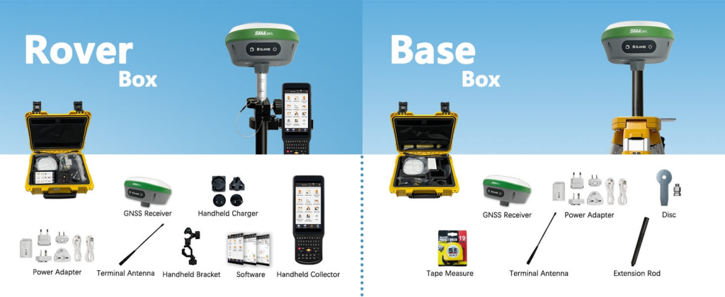
SMAJAYU SMA26 V2 RTK GPS Rover RTK Base Station
What Equipment Does It Include?
The SMA26 V2 RTK GPS Surveying System with IMU includes several important components. It comes with the SMA26 rover, base station, and a handheld collector with surveying software. This system is designed for precise surveying in construction and geodetic projects. The RTK GNSS receiver provides accurate positioning and measurement, allowing for quick and reliable data collection. The system can also be updated with new software to ensure it stays up-to-date.
What Sets It Apart?
The SMA26 V2 RTK GNSS receiver stands out for its accuracy. It supports various satellite systems, including GPS, GLONASS, and Galileo, making it adaptable to different environments. The system is designed to work in harsh conditions and deliver centimeter-level precision. It is also low-power, compact, and easy to carry. The built-in wireless modules and IMU make it a flexible tool for different surveying needs.
What Does the Surveying Engineer Need to Do?
To use the SMA26 system, the surveying engineer must follow these steps:
- Connect the collector with one SMA26 unit via Bluetooth to set it as the base station.
- Wait for 3 minutes for the connection to establish.
- Disconnect the base and connect the collector to the other SMA26 unit to set it as the rover.
- Set the same wireless protocol and channel on both the rover and base until the connection is stable.
- Once connected, start setting parameters and proceed with the surveying tasks.
Environmental and Sustainability Impact
Surveying Engineers' Contribution to Sustainable Farming Practices
Surveying engineers help make farming more sustainable. They do this by providing accurate data that helps farmers make better choices. With their help, farmers can use resources more efficiently, reduce waste, and protect the environment. By monitoring land and soil health, surveying engineers support sustainable farming practices that benefit both the farm and the ecosystem.
Ensuring Optimal Land Use and Reducing Waste
One of the key roles of surveying engineers is ensuring that land is used effectively. Through precise mapping and data analysis, they help farmers determine the best way to use their land. This reduces unnecessary land clearing and ensures that resources like water and fertilizer are used in the most efficient way possible. By reducing waste, surveying engineers contribute to more sustainable and eco-friendly farming practices.
Monitoring Environmental Impact Using Advanced Surveying Tools
Surveying engineers also play an important role in monitoring the environmental impact of farming. They use advanced tools, like drones and sensors, to track factors such as soil erosion, water usage, and pollution. This data helps farmers and environmental agencies assess the health of the land and take action to reduce negative impacts. Monitoring environmental effects ensures that farming practices remain sustainable in the long term.
Collaboration with Other Agricultural Experts
Working Alongside Agronomists, Environmental Engineers, and Farmers
Surveying engineers often work with other experts in agriculture. They collaborate with agronomists, who specialize in soil and crops, and environmental engineers, who focus on sustainable practices. By working together, they ensure that all aspects of farming are well-managed. Surveying engineers provide the technical expertise needed for accurate land measurements, while agronomists and environmental engineers contribute their knowledge about crops and ecosystems.
Importance of Cross-Disciplinary Collaboration for Maximum Efficiency
Collaboration is essential for efficient and effective farming. By working with experts from different fields, surveying engineers can contribute to well-rounded solutions. For example, when planning irrigation systems, the surveying engineer's data helps agronomists design more efficient water usage plans. The combined efforts of all experts lead to better farming practices and higher crop yields.
How Surveying Engineers Support Decision-Making Processes
Surveying engineers support decision-making by providing accurate data and analysis. Their work helps farmers make informed choices about planting, irrigation, and land use. With their expertise, they provide a clear understanding of land conditions, which is essential for planning agricultural activities. Surveying engineers help farmers make the best decisions for both the environment and their business.
Final Words
Surveying engineers are pivotal to the success of intelligent agriculture, leveraging advanced technology to assist farmers in optimizing land management and crop production. Their proficiency in mapping, data collection, and analysis enables more informed decision-making, supporting sustainable farming practices. By utilizing cutting-edge tools like drones and GPS systems, they gather precise data that boost productivity while minimizing waste. Working alongside other agricultural specialists, surveying engineers help promote efficient and environmentally friendly farming methods. Their contributions are vital for resource optimization, reducing environmental impact, and ensuring the long-term viability of agriculture.
