Have you ever paused to consider how towering skyscrapers rise with flawless precision, or how expansive highways extend smoothly across varying terrains without a hitch? The explanation can be found in the frequently underappreciated yet indispensable domain of Surveying Engineering. Absent this highly specialized discipline, many of the contemporary engineering wonders that define our cities and landscapes would be unfeasible to construct. Surveying engineers occupy a crucial role in sculpting the physical environment around us, supplying the exact measurements and essential data that underpin the development of infrastructure, the creation of accurate maps, and the effective management of land. But What is Surveying Engineering? And why is it of such paramount importance?

Surveying Engineering: Defining the Discipline
What is Surveying Engineering? Surveying Engineering is the science and art of accurately determining the position of points and the distances between them on the Earth's surface. It is much more than simply measuring land; it is the foundation upon which all civil engineering projects are built. Surveyors use cutting-edge technology, mathematics, and geospatial science to map land features, monitor construction progress, and ensure that structures are built in the correct locations with pinpoint accuracy.
At its core, surveying engineering ensures that what is designed on paper can be translated into reality with precision. By determining the exact positions of points and distances, surveying engineers lay the groundwork for everything from residential homes to complex transportation networks. Their work supports industries such as construction, urban planning, mining, and even environmental conservation.
The Importance of Precision in Surveying Engineering
Accuracy is the cornerstone of surveying engineering. Even the slightest error in measurement can lead to costly mistakes during construction or land development. Surveying engineers are responsible for ensuring that all measurements are precise, down to millimeters in some cases. Using tools such as GPS systems, total stations, and laser scanners, they can capture the precise dimensions and coordinates of any physical space. This high level of precision is essential for projects where structural integrity and public safety are paramount.
Surveying engineering is not just about getting the job done; it's about getting it done right. Whether determining the boundary lines for a new property or setting the foundations for a bridge, surveying engineers ensure that all aspects are in exact alignment with project specifications. The results? A safer, more reliable outcome that stands the test of time.
The Role of Technology in Modern Surveying Engineering
The technological advancements in surveying engineering have transformed the field in recent years. From theodolites and compasses used in early surveys to the modern-day utilization of satellite-based GPS systems and drones, the profession has evolved into a high-tech, data-driven discipline. Surveying engineers today rely on tools like Geographic Information Systems (GIS), 3D modeling software, and unmanned aerial vehicles (UAVs) to collect, analyze, and interpret spatial data more efficiently and accurately than ever before.
By leveraging technology, surveying engineers can conduct more complex projects, assess land conditions remotely, and deliver faster results. These advancements have not only increased accuracy but also made surveying more accessible for large-scale projects across different industries.
The R26 V2 RTK GNSS Survey Equipment by SMAJAYU, for instance, is an excellent example of how technology is used in the field. This tool integrates GPS, GLONASS, and Galileo systems to capture data in real-time with exceptional accuracy. Surveyors can use the R26 V2 for tasks ranging from construction layout planning to geodetic mapping, ensuring that every point on the land is precisely marked and measured.
Applications of Surveying Engineering in Different Fields
What is Surveying Engineering? Various Applications: The applications of surveying engineering are vast and impact a range of industries. Surveyors contribute to projects that define the landscape of cities, towns, and rural areas alike. From determining property boundaries to aiding in environmental conservation efforts, the data provided by surveying engineers is essential for modern development.

Construction and Civil Engineering
One of the primary applications of surveying engineering is in the construction and civil engineering sectors. Before any major construction project can begin, surveying engineers are brought in to measure and map the site. This ensures that structures are built in the correct locations, with proper alignment and orientation.
Ensuring Site Layout and Precision
Surveying engineers are vital in laying out the exact positions where buildings, roads, or bridges will be constructed. The R26 V2 RTK GNSS Survey Equipment is often used in these settings to ensure that the placement of each structure is accurate, from the foundation to the finishing touches. Surveyors use this technology to mark out the land according to the architectural designs, ensuring that the project proceeds smoothly without costly errors.
Monitoring Construction Progress
Throughout the construction process, surveying engineers continue to monitor the project’s progress to ensure that everything is built according to the plans. By taking precise measurements at various stages of construction, engineers can confirm that each phase aligns with the initial design. This prevents structural issues that may arise from misalignment, guaranteeing the integrity of the finished structure.
Complex Infrastructure Projects
For large infrastructure projects such as highways, bridges, or tunnels, surveying engineers play a crucial role. These projects require precision over long distances, and even a minor miscalculation can have a ripple effect. Surveyors use tools like the R26 V2 RTK GNSS system to provide the level of accuracy needed for these challenging projects, ensuring that roads, bridges, and tunnels are aligned correctly from start to finish.
Land Management and Property Boundary Disputes
Another key area where surveying engineering is applied is in land management and property boundary disputes. Property lines must be defined with absolute precision to prevent legal conflicts between landowners. Surveying engineers are called upon to provide official boundary surveys that establish the exact dimensions of a property.
Defining Property Boundaries
Surveying engineers help landowners understand the limits of their property by conducting detailed boundary surveys. These surveys are crucial in areas where land is valuable, and even a small discrepancy in the boundary could result in legal disputes. The R26 V2 RTK GNSS system by SMAJAYU helps surveyors pinpoint exact boundaries with high precision, ensuring that land disputes are settled with definitive data.
Land Use Planning
In addition to boundary disputes, surveying engineering is used in land use planning. Governments and developers rely on surveyors to map out land features, such as hills, rivers, and valleys, to ensure that developments are planned in a way that complements the natural environment. Surveying engineers provide detailed maps and data to support responsible land development and urban planning.
Environmental Conservation
Surveying engineers also play a role in environmental conservation by mapping out natural resources and sensitive areas. These surveys provide the data needed to ensure that construction or land use does not harm the environment. With tools like the R26 V2 RTK GNSS system, surveyors can work in even the most challenging terrain to gather accurate data that supports environmental protection efforts.
Surveying Technology: The R26 V2 RTK GNSS Survey Equipment by SMAJAYU
As surveying engineering evolves, the tools used in the field have become more advanced, providing surveyors with higher levels of accuracy and efficiency. One of the leading products in this domain is the R26 V2 RTK GNSS Survey Equipment by SMAJAYU. This system is designed to meet the rigorous demands of modern surveying, offering pinpoint accuracy and easy operation in a variety of applications.

What is the R26 V2 RTK GNSS Survey Equipment?
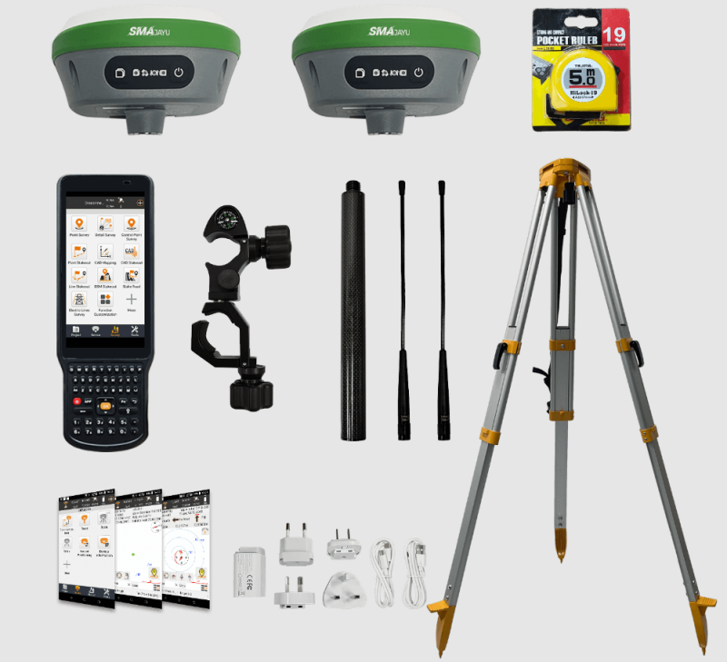
The R26 V2 RTK GNSS Survey Equipment is a state-of-the-art GPS surveying system that includes both a rover and base station, as well as a handheld collector loaded with professional surveying software. The system enables surveyors to collect precise measurements and reference positions in real time. Ideal for construction, geodesy and layout planning.
How Does It Work?
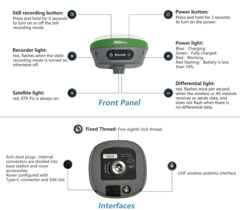
The R26 V2 RTK system works by connecting a collector with the rover and base station via Bluetooth. The base station is set up first and acts as a reference point. Once connected and configured, the rover is used to survey the site. By ensuring both devices are synced through the same wireless protocol, surveyors can achieve centimeter-level accuracy in their measurements. This system is not only easy to use but also versatile enough to be deployed in a wide range of surveying tasks, from urban construction to rugged terrain mapping.
Where is the R26 V2 Used?
The R26 V2 RTK GNSS system is used in a variety of surveying applications, including:
Construction and civil engineering projects, where accurate positioning is critical.
Geographic information systems (GIS) and mapping.
Environmental monitoring and land use planning, where accuracy and real-time data are essential.
Mining and quarrying operations, where precision is needed to map out the excavation areas.
Why Choose the R26 V2 for Surveying?
The R26 V2 RTK GNSS system offers several advantages, including its compact design, low power consumption, and ease of use. It supports GPS, GLONASS, and Galileo satellite systems, ensuring reliable performance in even the most challenging environments. Additionally, the built-in Bluetooth and wireless modules make the setup process straightforward, allowing surveyors to start their tasks without unnecessary delays.
Choosing SMAJAYU: A Trusted Partner in Surveying Engineering
For surveying engineers, having the right tools is crucial to the success of their projects. SMAJAYU is a leading supplier of high-quality surveying equipment, offering reliable products like the R26 V2 RTK GNSS Survey Equipment. SMAJAYU products are known for their precision, durability and ease of use. They are trusted by construction, land management and geospatial science professionals around the world.
Commitment to Quality and Innovation
SMAJAYU is committed to delivering innovative solutions that meet the ever-evolving needs of the surveying industry. Their products are designed using the latest technology. Ensure surveyors have access to tools that deliver the accuracy and reliability modern projects require.
Technical Support and Customer Satisfaction
In addition to high-quality products, SMAJAYU offers exceptional customer support. Surveyors can reach out to their technical team for help with setup, troubleshooting, and ensuring the equipment works perfectly. With instructional manuals, online resources, and a dedicated support team, SMAJAYU ensures that its customers are well-equipped to handle any surveying challenge.
What is Surveying Engineering? Surveying engineering is a vital field that supports the development of our physical world. With the right tools and technology, like the R26 V2 RTK GNSS Survey Equipment from SMAJAYU, surveying engineers can continue


