

In today’s rapidly evolving landscape of geospatial technology, where the need for accurate data is becoming increasingly paramount, precision takes center stage. If you find yourself working in areas such as surveying, construction, precision agriculture, or any field where accurate positioning is a non-negotiable requirement, chances are you’ve come across the terms PPK (Post-Processed Kinematic) and RTK (Real-Time Kinematic). However, have you ever stopped to wonder what really differentiates these two sophisticated technologies, and more importantly, which one is better suited for your unique needs?
What is the difference of PPK and RTK: To unravel this, we will delve into the intricate world of GNSS (Global Navigation Satellite System) technology, offering a comprehensive breakdown of the core differences between PPK and RTK. These two cutting-edge methods provide professionals with the ability to obtain precise location data critical for a wide range of applications.
What Exactly Are PPK and RTK?
What is the difference of PPK and RTK: Before we dive into a detailed comparison, it’s vital to first understand the fundamental principles behind both PPK and RTK, as well as their significant roles in GNSS-based solutions.
PPK: Post-Processed Kinematic
PPK, short for Post-Processed Kinematic, refers to a GNSS data processing method where raw satellite signals are captured by both a base station and a mobile GNSS receiver, but—and here lies the key distinction—data processing does not occur immediately. Instead, the satellite data is subjected to post-processing only after the collection phase has concluded.
This methodology becomes especially advantageous in scenarios where establishing real-time communication between the base station and the rover proves to be challenging, such as in obstructed or remote environments. With PPK, accuracy is achieved through offline correction, comparing data from the base station with that from the mobile receiver, ensuring a high level of positioning precision.
RTK: Real-Time Kinematic
In contrast, RTK operates on a real-time basis, where the base station continuously transmits correction data directly to the mobile GNSS receiver (rover) as the satellite signals are received. The result? Real-time, centimeter-level accuracy that can be instantly applied in the field.
This technology relies on the uninterrupted transmission of correction data, typically via UHF radio or cellular connectivity. RTK is indispensable in tasks that demand instantaneous precision, such as construction layout, surveying, machine control, and precision farming.
Critical Differences Between PPK and RTK
What is the difference of PPK and RTK: Although both PPK and RTK methodologies aim for high-precision positioning, their differences in approach, requirements, and use cases make them suitable for different situations. Let’s dive deeper into what sets them apart.
Data Processing Timing: Post-Collection vs. Real-Time
Perhaps the most noticeable difference between PPK and RTK is the timing of data processing:
PPK is focused on post-collection processing. This means that during the data-gathering process, no real-time connection between the base and rover is necessary, offering greater flexibility. The corrections are applied after the data collection is complete, making it especially advantageous when real-time communication is hard to maintain.
RTK, on the other hand, shines in its real-time correction ability. The base station transmits precise corrections instantaneously to the rover, allowing for immediate adjustments. This makes RTK ideal for situations where on-the-spot accuracy is crucial.
Communication Requirements: Flexibility vs. Continuity
Another major difference revolves around the need for constant communication:
PPK thrives in environments where real-time connectivity isn’t viable. Since data correction occurs after collection, continuous communication between the base station and the rover is unnecessary. This makes it particularly useful in areas where maintaining stable connectivity, such as in remote or obstructed terrains, is a challenge.
RTK, however, depends heavily on a stable, continuous communication link between the base and rover. If this connection falters or is interrupted, the accuracy of real-time data can be compromised. Thus, RTK may struggle in environments with poor connectivity, such as heavily wooded areas or mountainous regions.
Accuracy and Reliability: Post-Processed vs. Immediate Results
While both PPK and RTK deliver high-precision results, the environment and circumstances can dictate which method is more reliable.
PPK offers enhanced accuracy in complex environments, thanks to the flexibility of post-processing corrections. If satellite signals are obstructed or interrupted, the data can still be refined and corrected later, ensuring reliable outcomes even in challenging conditions like urban areas or dense forests.
RTK, meanwhile, provides immediate, real-time accuracy, making it indispensable for time-sensitive projects. However, this real-time processing depends heavily on maintaining a stable connection between the base station and rover. When the connection is reliable, RTK’s accuracy can be exceptional, but it may suffer in signal-obstructed environments.
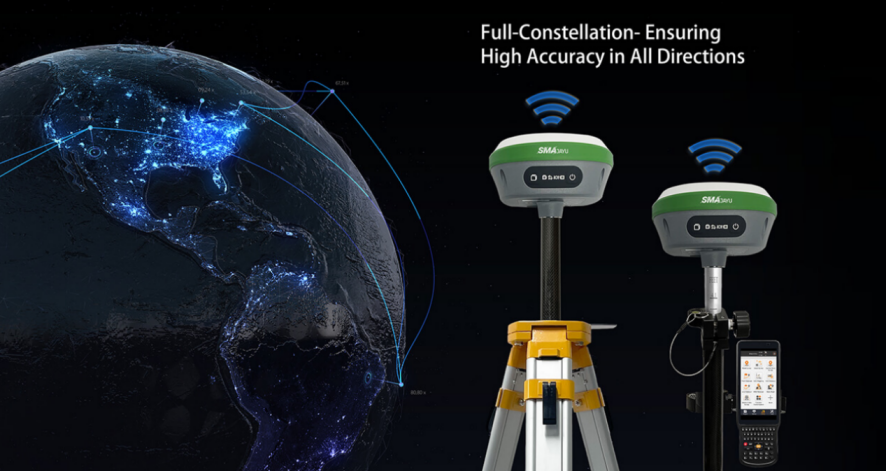
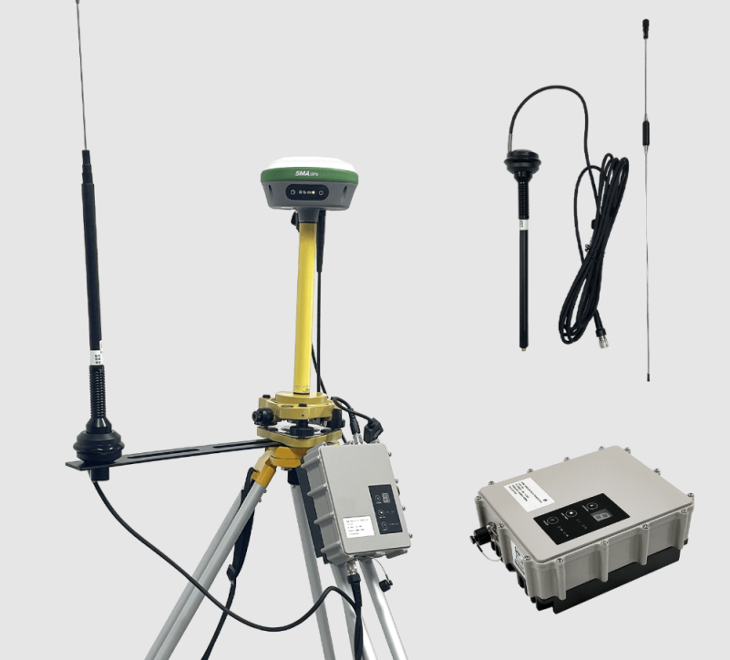
The SMA26 RTK Base: Elevating Precision Surveying
Now that we’ve explored the key differences between PPK and RTK, it’s time to take a closer look at an advanced GNSS tool that exemplifies the power of these technologies: the SMA26 RTK Base from SMAJAYU. This multifunctional GNSS receiver brings the latest in surveying technology to the forefront.
Intelligent and Versatile Design
The SMA26 RTK Base is a highly sophisticated GNSS receiver, designed to offer unparalleled precision in various applications. Whether you’re conducting detailed land surveys, precision agriculture, or geodetic mapping, the SMA26 is engineered for optimal reliability and ease of use.
Equipped with a GNSS full-frequency antenna and high-precision positioning board, this device excels in delivering the accurate data required for geodetic surveys, machine control, aerial photography, and more.
Engineered for Tough Environments
Fieldwork often takes place in harsh, unpredictable environments. The SMA26 is built with durability in mind. Its powerful 10200mAh battery offers over 14 hours of continuous operation, ensuring long-lasting performance even in remote areas.
Moreover, the device features a built-in UHF wireless transceiver, enabling smooth switching between mobile and base stations. The CSS (Lora) protocol further ensures strong, long-distance signal transmission, reaching up to 20km, providing reliable connectivity even in large-scale projects.
Comprehensive Signal Tracking
The SMA26 RTK Base stands out with its ability to track signals from 1408 channels across all GNSS constellations, including Beidou-3. This extensive signal-tracking capability ensures superior performance, even in challenging environments where satellite signals may be weak or obstructed.
When to Choose PPK vs. RTK with the SMA26
What is the difference of PPK and RTK: Deciding between PPK and RTK depends on the specific requirements of your project and the environmental conditions. Here’s a quick guide to help you determine which method is most appropriate:
PPK for Flexible Post-Processing
PPK is ideal when working in areas where constant connectivity is either difficult or impossible to maintain. If you’re surveying in dense forests, remote mountainous regions, or urban canyons where real-time communication is unreliable, PPK allows for offline corrections, ensuring you still achieve the necessary precision.
With the SMA26, you can confidently collect data in even the most challenging environments, knowing that post-processing will correct any inaccuracies.
RTK for Real-Time Accuracy
RTK is the go-to method when immediate, real-time positioning is crucial, such as during construction layout planning or machine control operations. If your project location provides reliable communication between the base and rover, the SMA26 RTK Base delivers accurate, real-time positioning that allows for on-the-spot adjustments.
The SMA26’s optional external radio and long-range signal capabilities make it perfect for large-scale projects where maintaining a steady connection over distances of up to 20km is essential.
Conclusion: Leveraging the Strengths of PPK and RTK
Ultimately, the choice between PPK and RTK depends on the unique demands of your project. PPK offers flexibility in post-processing, making it suitable for difficult environments, while RTK delivers immediate precision in locations with stable connectivity.
With the SMA26 RTK Base from SMAJAYU, professionals can take advantage of both PPK and RTK methodologies. This state-of-the-art GNSS receiver is equipped to handle a wide range of workflows, making it an indispensable tool for surveying, construction, agriculture, and beyond.
Whether your project takes you deep into a remote wilderness or demands real-time precision on a construction site, the SMA26 delivers the accuracy and reliability you need.
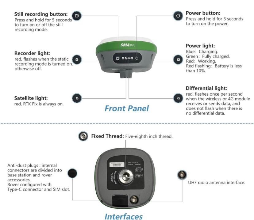
Pro Tip: Before using your SMA26 for the first time, ensure that it’s fully charged by connecting it to the provided adapter. A simple press of the power button will activate the device, allowing you to harness the power of precise GNSS surveying with ease.
